The Lumberjack


Students Serving The Cal Poly Humboldt Campus and Community Since 1929

Tag: explorehumboldt

  • #ExploreHumboldt: Arcata Marsh

    #ExploreHumboldt: Arcata Marsh

    Try and lose yourself in the Arcata Marsh for the best experience

    Welcome back to the #ExploreHumboldt column, your source for accessible natural areas to visit in your spare time. This week, we’ll look at a unique, double-duty location that serves as a wastewater treatment facility and a beautiful habitat for countless bird species: the Arcata Marsh!

    This 307-acre sanctuary is located in southern Arcata, and can be accessed from South G and I streets. This places the marsh within a 15-minute walk or a five-minute bike ride from campus.

    The Marsh’s interpretive center provides information on the wide variety of bird species that frequent the marsh, and how the marsh filters Arcata’s wastewater into clean water that can be released back into the bay. | Photo by Jett Williams

    Any trip to the Marsh should start at the Interpretive Center. There, you’ll find installations detailing the many exotic bird species that stop at the marsh on their migratory journeys up and down the coast. So far, over 300 unique bird species have been spotted in the marsh this year. Some of these are extremely rare, or are typically found on the East Coast.

    From the Interpretive Center, multiple trails spiderweb out to every corner of the park. In total, there are about 5.4 miles of mostly gravel trail, with some paved sections. Strategically-placed maps ensure that you won’t get lost and provide interesting information on the park’s science and history.

    But, as with any natural area, the best way to get a lay of the land is to get lost. Around every corner is another table or bench overlooking a scenic view, or an enclosed shelter for birdwatchers to observe the local wildlife.

    Organized nature walks are a good way to experience the marsh in a social environment, with experienced birdwatchers who can point out and identify rare bird species. | Photo by Jett Williams

    If you want a recommended route to get started, begin at the Interpretive Center and head north along the west side of Butcher Slough Log Pond. Turn left and follow the trail as it winds around Brackish Pond.

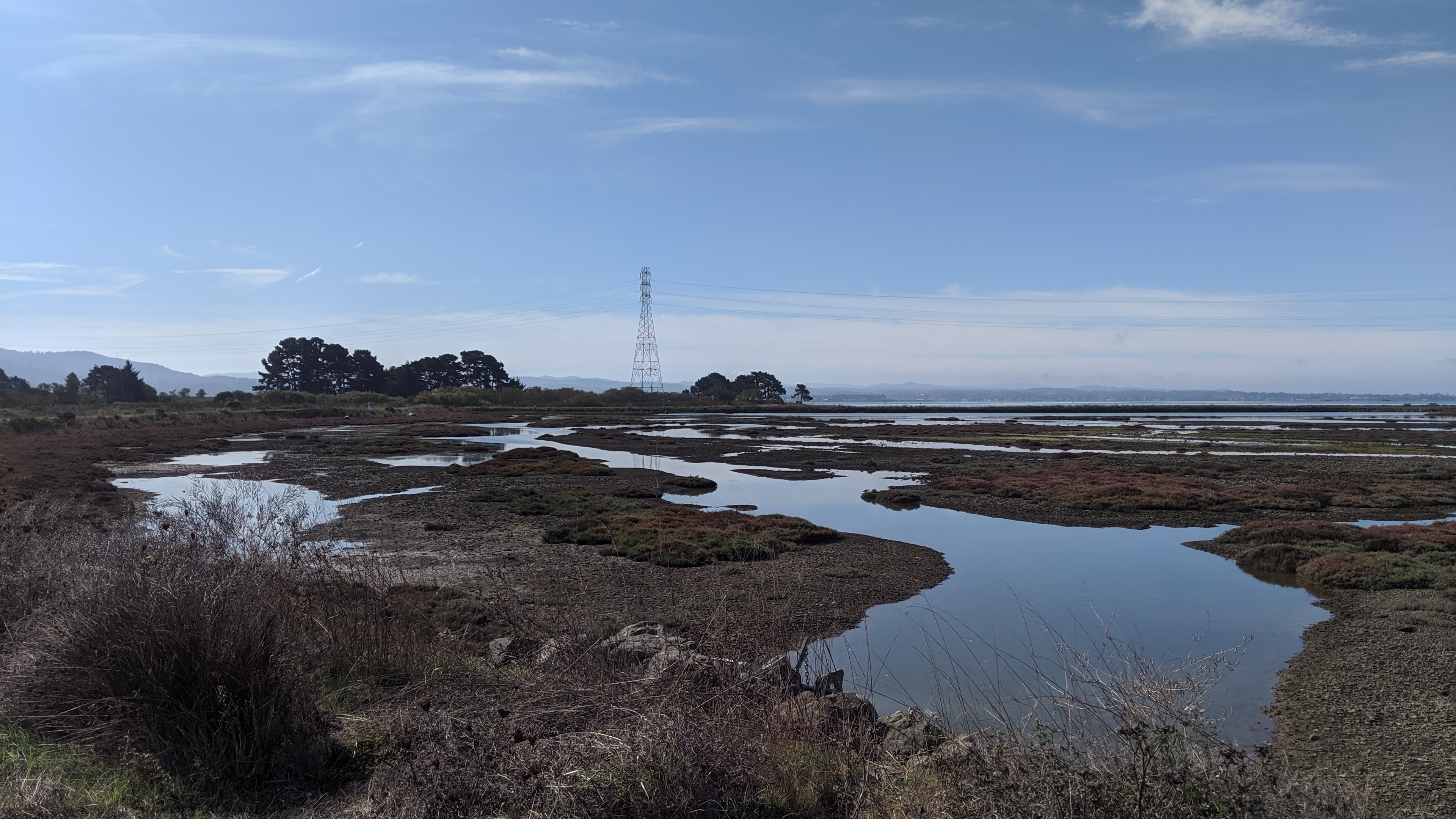
    This time of year, Brackish Pond is covered in a layer of green algae that gives it a surreal look and is a hotspot for birds. Stop at the bird viewing station on the northwest corner before heading south past Gearheart Marsh, and looping back to the Interpretive Center.

    In addition to being a nearby natural spot to get out to for some nature time, the Arcata Marsh serves as a wastewater treatment plant. Algae and bacteria help to purify the water as it moves through the different ponds of the marsh.

    One can spend hours wandering the marsh, checking out the different ponds and looking for exotic bird species. The marsh is expansive and rarely crowded, offering ample opportunities for seclusion. | Photo by Jett Williams

    Eventually, the water is sterilized with chlorine and flows back into the Humboldt Bay. This system allows Arcata to manage its wastewater production while providing a refuge for local wildlife and a local park for residents to enjoy.

    If you’d like to check out the Arcata Marsh with the help of experienced and knowledgable guides, there are several guided marsh walks available. Friends of the Arcata Marsh meets every Saturday at 2:00 p.m. at the Interpretive Center for a guided marsh walk.

    For those looking to learn more about the many bird species that call the marsh a temporary home, the Redwood Region Audubon Society meets for guided birding walks every Saturday at 8:30 a.m. This walk meets at the I street parking lot.

    The Arcata Marsh is an amazing free resource for students in need of a quiet oceanside spot to explore and relax in. Get it while you can, and don’t forget to #ExploreHumboldt!

  • #ExploreHumboldt: Hammond Trail and the North Coast

    #ExploreHumboldt: Hammond Trail and the North Coast

    Hammond Trail and Scenic Drive offer numerous natural areas to visit

    Hello and welcome to the #ExploreHumboldt column, the HSU student source for the most stunningly scenic natural areas close by. For this week’s column, I’m doing something a little different.

    Instead of giving you one condensed area to check out, I’ll be going over some of my favorite spots along the stretch of coastline just north of here. This article barely scratches the surface of what’s out there, so as always use this as a guide for your own adventures.

    The Hammond Trail starts at the Mad River Bridge in the Arcata bottoms. | Photo by Jett Williams

    It all starts with the Hammond Trail. This 5.5-mile, mostly paved line follows the coast up from the Arcata bottoms to Clam Beach, just north of McKinleyville. To get there, take Janes Road to Upper Bay Road, and turn right onto Mad River Road. Follow this until you come to the trailhead.

    Hammond Trail starts at an old footbridge spanning the Mad River, decorated with typical Humboldt graffiti and a series of padlocks attached to the rusty chain-link fence. The trail was voted “Best Place to Walk, Jog or Bike” in a Times-Standard poll, and alternates between roads and paved pedestrian trail as you make your way through McKinleyville.

    The Mad River bridge has several padlocks, ranging from rusty and old to fresh, dangling from its chain links. | Photo by Jett Williams

    After meandering along for roughly 5 miles, you will make your way to Clam Beach County Park. This spot offers sandy beach access, paid camping spots and scenic picnic tables with BBQ pits. A solid destination for a weekend excursion, or a nice rest spot during a run or bike ride, but the best locations are still further north.

    Unfortunately, this is as far as the Hammond Trail goes. To get to the real goods along the aptly-named Scenic Drive, you can take your vehicle of choice onto the freeway at the end of Clam Beach Drive, then take the first exit for Westhaven Drive. Turn left, then right to continue north on Scenic.

    The Hammond Trail has an optional section for hikers only that traces the local watershed, and provides a quieter hiking option. | Photo by Jett Williams

    If you’re on foot or don’t feel like biking on 101, it’s probably better to park in Clam Beach, walk the trail, then come back and drive to Scenic. There are plenty of places to park once you reach the road. Alternatively, you could park in Trinidad and ride a bike down the road from there.

    It should be noted that taking a bike on the freeway carries a whole host of extra risks, and should not be done frivolously. Wear bright colors and use a daytime taillight to ensure that you’re seen by motorists, never take longer on the freeway than you absolutely have to and don’t forget your helmet!

    Multiple footbridges like this one can be found along the Hammond Trail. | Photo by Jett Williams

    Scenic Drive is aptly named, and first-timers will find it difficult to keep their eyes on the road as they’re treated to vista after vista of rugged northern coastline. But sections of the road turn unexpectedly to gravel and it becomes single-lane in a few areas, so it’s best to keep your wits about you.

    Around every corner are turnouts and parking lots for the many beaches and access points along the road. One of my personal favorites is Baker Beach. This secluded beach is dotted with monstrous coastal boulders, scalable at low tide but inaccessible when the waves roll in. Baker Beach is also clothing-optional, but you won’t get kicked out if you prefer to keep it in your pants.

    Baker Beach provides scenic seclusion. During low tide, one can climb the rocks in the center frame. | Photo by Jett Williams

    Near this beach are two of my favorite spots, a hidden swing that looks to the southern coast, and a treehouse platform with two chairs that looks to the north with mind-blowing views of Trinidad Head. Not all spots are for everyone, so I’ll leave the details of the exact location up to you to find. If you get out to the beach, finding these locations is fairly straightforward as long as you look around.

    After Baker Beach, it’s a short jaunt along Scenic Drive to get to Trinidad. While you’re there, check out The Lighthouse Grill. I recommend the Mashed Potato Cone (a Lighthouse Grill staple) and the Jalapeño Jelly Burger (an acquired taste).

    The access trail to Baker Beach is clearly not handicapped-accessible. | Photo by Jett Williams

    The best thing about this stretch of coastline is its different options. You can park in Trinidad and bike south along Scenic, park at Clam Beach and jog or walk south or leave from Arcata and ride the whole thing.

    Whatever you decide, the point is to do something. Make these days count, as soon we’ll be trapped under an oppressive sheet of rain. Find some time, and don’t forget to #ExploreHumboldt.

  • #ExploreHumboldt: Patrick’s Point

    #ExploreHumboldt: Patrick’s Point

    Patrick’s Point offers multiple options for beach-lovers at an affordable price

    This week’s #ExploreHumboldt column covers a fan favorite, the majestic and expansive Patrick’s Point. This one-square-mile State Park features some of the best beach spots around and is a perfect destination for a daytime picnic, sunset beach run or weekend camping trip.

    As a state park, Patrick’s Point includes amenities that we have not seen in previous #ExploreHumboldt entries. These include bathrooms with running water, clearly marked trailheads with accurate mileage, picnic tables with BBQ grills and over 120 overnight camping spots.

    Because of its State Park status, Patrick’s Point has well-maintained and clearly-marked trails with mileage indicators. | Photo by Jett Williams

    However, these benefits come at a cost. There is a $8 vehicle fee, with no student discount. The litany of areas to explore and the overall quality of the experience make it worth the price of admission. You should leave a couple hours of time minimum to to fully experience the park and get your money’s worth.

    Patrick’s Point also features several “Hike n’ Bike” campsites. Those who bike or hike into the park benefit from free admission as well as their own area with campsites reserved for non-car users. These sites include all the features of a car site, with a location closer to the best points of interest.

    The view looking north from Wedding Rock is one of the most spectacular in the park. The beach access trail can be seen in the bottom left corner. | Photo by Jett Williams

    To get to Patrick’s Point, take Hwy 101 north past Trinidad, and take the ‘Patrick’s Point’ exit. Turn left, and continue until you see signs for the park. Alternatively, you can drive to Trinidad and bike along Stagecoach Road, turning left onto Patrick’s Point drive before arriving at the park. This way, you get a bit of extra exploration in, while avoiding the $8 vehicle fee.

    If you want to see everything, it’s worth bringing some hiking shoes and a day pack to walk the length of the park. There are a ton of different spots to visit at Patrick’s Point, so I’ll quickly go over some of my favorites.

    Sea Anemones are easily found at the tidepools near Palmer’s Point during low tide. Tide tables are available online and at the park’s entrance. | Photo by Jett Williams

    A network of trails connects the different points of interest spread throughout the park. Plan to hike at least a couple of miles if you want to see everything. Most of the main rim trail is fairly flat and some sections are wheelchair-accessible. However, the access trails that take you to most of the prominent locations are very steep, as they often run straight up and down the steep coastal hills.

    Wedding Rock is the most spectacular point in the park. This massive rock structure juts up from the coastline, providing stellar views of the surrounding rough coastline. The park’s original caretaker was married there in the early 1900s, and Wedding Rock has been home to several weddings every year since.

    Sumeg Village is a recreated Yurok village, built by the local tribe with modern tools and traditional materials and practices. The village is used by the tribe for cultural traditions and features two redwood canoes, a sweat room and a native plant garden, also maintained by the tribe.

    Sumeg Village provides a nice spot for quiet reflection. The area was built with traditional Yurok techniques by the local tribe, and is still used today for rituals and ceremonies. | Photo by Jett Williams

    The Agate Beach is another location worth your time. This expansive stretch of coastline seems to span as far as the eye can see, with a pristine beach of light sand and naturally-occurring agate stones.

    When visiting Patrick’s Point, remember that swimming in the frigid North Coast waters is highly discouraged. The undertow is strong, and sweeper waves can catch unattentive visitors off-guard. Dogs are allowed, on-leash only, but are not permitted on trails or beaches. Also, refrain from picking the local mushrooms and wildflowers. They have a hard enough time surviving without being plucked by the unaware.

    After a long school week, we all need a bit of calm reflection and relaxation. Carve out at least an afternoon later this week or this weekend to visit our closest state park, and don’t forget to keep exploring!