The Lumberjack


Students Serving The Cal Poly Humboldt Campus and Community Since 1929

Tag: Geology

  • Geology students dig deep during 20th annual geology expedition

    Geology students dig deep during 20th annual geology expedition

    by Harrison Smith

    Since 2003, the CPH Geology department has been bringing students to various geologically significant sites across the western US during a marathon spring break field trip. This year marked the twentieth anniversary of Geology 110: Field Geology of the Western United States, uninterrupted by even the pandemic, and the retirement of veteran geology professor Mark Hemphill-Haley.

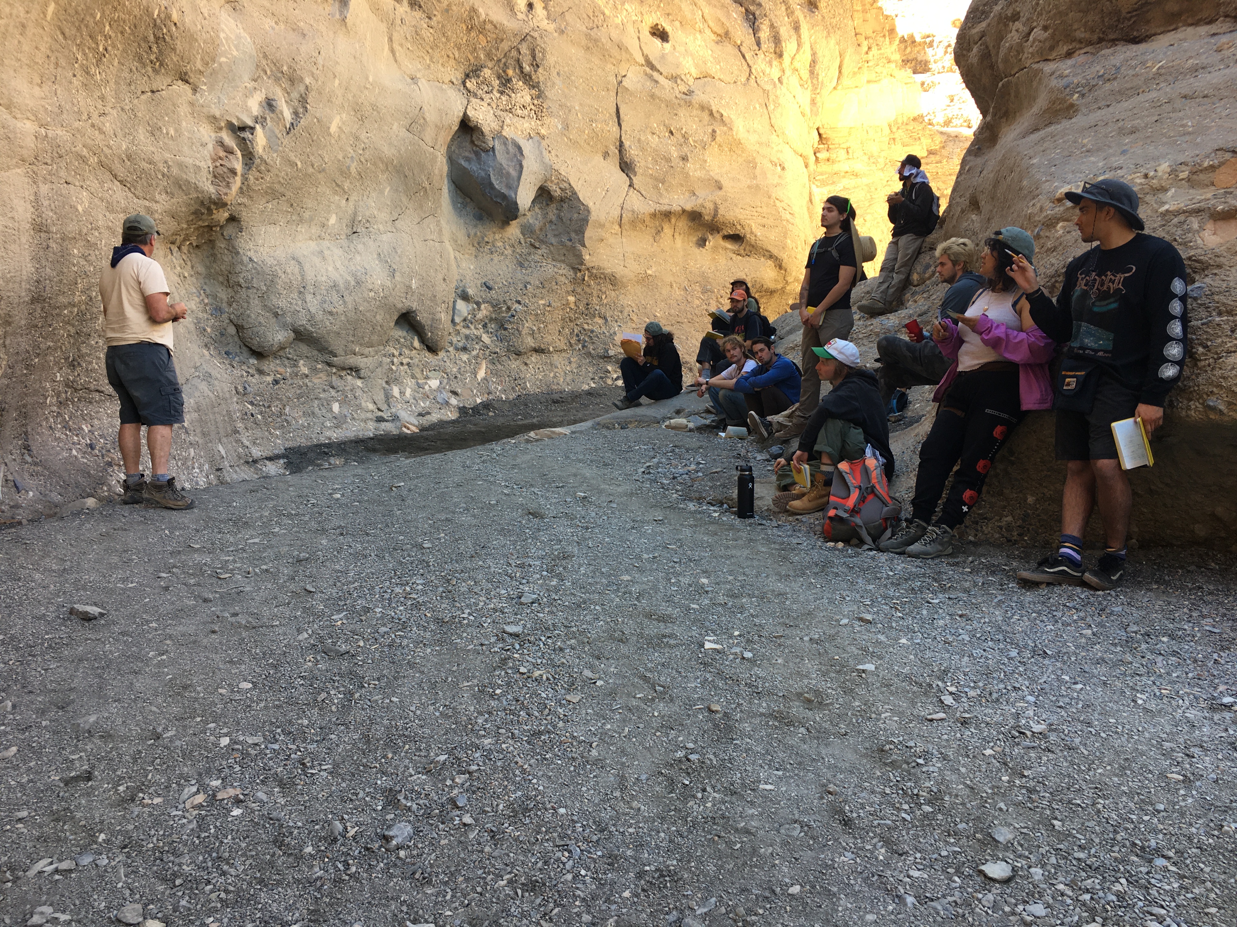
    At 8am on March 11, all twenty members of the 2023 Geology 110 expedition met at Van Matre Hall weighed down with our camping gear to load into the four vehicles that would be our homes for the next two solid days as we drove to Death Valley.

    The Bonanza King Formation is a massive bed of carbonate rock that constitutes much of the boundary between Nevada and California. It is visible in many places across both states, but at Point of Rocks, it dominates the landscape. There, tilted beds of Bonanza King carbonate cut through the terrain like the ribs of a dead giant, draped in loose alluvium that slants down to the desert flats. 

    The footing on the ridge was treacherous. Skree slid under my feet as I moved up the slope, conscious only of the $500 Brunton Compass in the case at my belt and the possibility that I might drop it in front of everyone. I looked down, and, deciding that the bed at my feet was good enough, knelt to remove the Brunton from my belt case. In the protection of my big straw hat, I carefully lay the edge of the compass flush on the top of the carbonate bed, tilting it this way and that in a futile attempt to find the striking angle of the bed. It was exhilarating to finally be practicing a geology skill in the field. We were learning to measure the striking angle of a rock bed, which is the compass heading at which it cuts the ground, and I was determined to find it myself. In conjunction with the dip, which is the angle at which the bed descends into the ground, strike-dip measurements of rock beds and faults provide a picture of what’s going on under the surface. Finally, I set aside my pride and looked around to find Michelle Robinson, geology alum extraordinaire, who was down the ridge helping another student. 

    “Michelle, can you help me with this strike?” She smiled. Of course– this trip was all about learning. Each one of the students I spoke to about our experiences on the 2023 Death Valley trip said something similar. 

    “It was a little difficult to ask questions, but as soon as you understand that no one is judging you, it’s a perfect open environment,” third year geoscience student Jane Martinez said. 

    My experience was the same– at first, I felt in awe of the older students. They seemed to know exactly which questions to ask at each of the stops we made along the way, but I never felt too intimidated to ask my own questions. Every interaction was a reminder that science is not a competition, but a collaboration. 

    “At first, I was pretty shy too, but I just liked the fact that some of my upperclassmen helped me out with terms that I didn’t know and they were always giving me information on the simplest questions, and I really appreciated that,” said Daniel Abel, a third year geology major. “If I’m with someone new, I’m going to help them out as much as I can with the information that I have, so that they can get better and smarter with geology.”

    This trip was an extremely valuable experience in that it allowed geology students to form bonds with their peers.

    “I feel like I made a lot of really good friends over the trip and it’s kind of hard to do that sometimes,” Abel said. “I really appreciate that.” 

    Mark Hemphill-Haley has been associated with Humboldt’s geology department for decades, first as a student and then as a professor. 

    “The thing that excited me about geology when I first came to Humboldt was the enthusiasm that the department and the students shared about learning geology, and the depth of knowledge of the faculty and their excitement,” Hemphill-Haley said. “I think at Humboldt students in general are a little different than some other universities. You know, it’s a little harder to live here in some ways. So I feel like people that are here really want to get their life’s worth out of the programs. And so I just think that the students are special.”

    Trips like Geology 110 and the connections made during those trips are what make Humboldt special. “The thing that I’ve noticed from when I was an undergrad to students now is, we’re still the same,” Hemphill-Haley said.

  • Aftershock: the nuance of Humboldt geology

    Aftershock: the nuance of Humboldt geology

    by Harrison Smith

    Hey – did you feel it? That little jolt? The coffee on your desk is even rippling! I think we just felt an aftershock! 

    For some, aftershocks are a fun little jolt that give you something to talk about in line at Los Bagels. For others, they are terrifying reminders of Humboldt’s earthquake vulnerability. 

    For almost a month following the Dec. 20 earthquake that devastated parts of the county, over 80 aftershocks of magnitude 2.5 or greater have gently shaken Humboldt- most too small to be felt. Large earthquakes in fault-prone areas like Humboldt may change the stresses on adjacent faults. 

    “The kind of earthquake that fault produced, with that kind of slip, can produce a pattern of stresses which, in some instances can promote a nearby fault to be closer to failing,” said Dr Mark Hemphill-Haley, a geology professor at Cal Poly Humboldt.

    Some shifts release stress to delay an earthquake, while some increase stress. This can trigger new movement as the fault system searches for a new equilibrium. The pattern of aftershocks can provide important clues into the state of the fault system. 

    “From just the 2.5s, you can kind of get an idea of how they ruptured along the subduction zone,” said John Bellini, geophysicist at the USGS National Earthquake Information Center. 

    However, accurate triangulation of the Ferndale quake’s epicenter and those of its aftershocks is complicated by the fact that the fault system lies largely offshore. 

    “Because all of the stations are onshore and the main shock was just offshore, you don’t get as meaningful distribution,” said Bellini.

    Judging from the distribution of the aftershocks, one might think that they followed East-Northeast running faults. However, data is often deceptive. 

    “If you look at the trends of the faults, they are Southeast to Northwest,” said Bellini. “This misleading artifact of the map is due to imprecision in triangulation- in order to locate the epicenter of an earthquake, it must be recorded from three different seismic stations.” 

    The more surrounded the earthquake is by seismic stations, the greater one’s ability to measure it precisely. Because the closest ‘western’ seismic stations are in Hawaii, precise observation of seismic activity off the Humboldt coast is difficult. 

    Image courtesy of USGS | Fault distribution in the North American Plate.

    “Most of the stations for most of those quakes are going to be to the east, with nothing to the west for most of them… when that happens, the error ellipsoid for them is going to be stretched in an east-west direction,” said Bellini.

    Humboldt County sits at the very south tip of the Cascadia subduction zone, where the Gorda/Juan de Fuca, Pacific and North American tectonic plates come together in a geologically complex region called a triple junction. 

    The difficulty of studying the complex tectonic interactions at this triple junction is compounded by the fact that it lies half offshore, however new developments in geology have lifted the veil on offshore tectonics. 

    Last summer, researchers from Cal Poly Humboldt’s geology department along with researchers from the US Geological Survey, UC Berkeley, and University of Washington installed over 40 seismometers along an optical fiber cable that runs from Aracata to Eureka. Instruments connected to the optical fiber along with the seismometers provided high resolution about the local seismicity. The instruments were removed after their testing period was complete, but they were reinstalled immediately in the aftermath of the Dec 20, 2022 Ferndale earthquake. 

    The use of fiber optic cables for monitoring earthquakes is very recent, but a huge development for geology in areas like Humboldt.

     “We’ve already recorded more than a hundred aftershocks associated with that recent quake,” said Dr. Hemphill-Haley.

  • Field Camp tests geology students’ knowledge and endurance

    Field Camp tests geology students’ knowledge and endurance

    by August Linton

    Field Camp for Cal Poly Humboldt’s geology majors is a month-long academic camping trip, and a foundational experience in the field that geologists remember with love. 

    Local field trips to places in Humboldt like Agate Beach and Big Lagoon are testing grounds for students used to dusty labs on campus. The university has a large library of rock samples, but students enjoy collecting their own. 

    “Agate Beach was a good one,” said Riley Clark, a CPH graduate and Field Camp returnee. “I’ve had structural geology trips there to look at faults and things like that, and sedimentary geology trips there to look at marine sediments.”

    Geology department classes teach both book knowledge and field techniques. One class called petrology, about the origin and microscopic structure of rocks, uses a technique called thin sectioning. With careful sanding, epoxy, and heat, students can make microns-thick samples of rock for microscope analysis. Field trips give students the opportunity to use these techniques at actual sites rather than in a lab.

    From May 29 to June 29, students from the program visited teaching sites in California’s Eastern Sierras for their capstone Field Camp, which is a more intense iteration of the geology field trip. Other geology programs also visit those same sites.

    “The first field site we went to we were alone, then at the next site there was Sac State, Montana State, a class from Wyoming, Northridge was there,” said graduated geology student Nay de la Torre. 

    Field Camp is analogous to a capstone project for geology students, a field-wide tradition that most programs participate in. It teaches students how to apply their knowledge, but also 

    Photo courtesy of Riley Clark | Roch Creek, an area that students were tasked with mapping near Bishop, California
    Photo courtesy of Riley Clark | Roch Creek, an area that students were tasked with mapping near Bishop, California

    The Poleta Formation is a common teaching location located in the Eastern Sierras, where different layers of sediment are exposed and can tell geologists about the geologic history of that place. 

    “It was deposited during the Cambrian…when California was covered in a shallow sea,” said de la Torre. “You could walk from LA to Las Vegas with water up to your knees.”

    This shallow sea still had tidal action, which geologists can tell based on those layers.

    “The tide would come in and come out, so during this time sandstone would be deposited, then when the tide went out the water would evaporate and deposit carbonate rocks like limestone,” de la Torre said.

    At a second location in the Inyo-White Mountains, students spent time studying igneous intrusions into the crust, called plutons. There are also several wide-reaching fault systems that span the area, which students were tasked with mapping. 

    “At one of our sites we saw a series of faults and then at another one we saw a series there,” said Clark. “It was neat to correlate those…we know that the same compression on the continent caused it.”

    De la Torre says this trip stretched the students to their limits mentally and physically.

    “Everything that you’ve learned, you use it at Field Camp, with every class since freshman year,” said de la Torre. “You don’t really have time to do much else other than go to the field, eat dinner, and go to sleep, cause you’re so tired every single day.”

    Weeks of complete isolation from everything other than a small group of colleagues, six to nine miles of hiking every day in baking sun, and living in tents for a month taxed the students, but also galvanized them. Their daily tasks, like surveying areas for map-making, mirror what they will be asked to do in their careers as geologists.

    “Field Camp feels like something that I’m going to remember for the rest of my life, because all the older geoscience people that I talk to still remember their Field Camp,” de la Torre said.

  • Humboldt State Geologists Research Faults

    Humboldt State Geologists Research Faults

    Faults give clues to the history of the earth’s crust and how it impacts our future

    Earthquakes are more than just shaking. Turns out the rumbling is sound vibrations from the massive snap caused by slipping, bending and breaking rock.

    Deep below Earth’s crust, a mantle of plastic-behaving rock bends and twists under immense pressure. Its mass is 67% of the Earth’s mass. Its temperature ranges from 392 degrees Fahrenheit at the upper boundary of the crust to an incendiary 7,230 degrees Fahrenheit at the core-mantle boundary. Sometimes the overlying, thin 50 to 20 kilometer thick crust cracks.

    “The earthquake is the sound waves moving through the rock, elastic waves propagating through it,” said Dr. Mark Hemphill-Haley, a Humboldt State University neotectonics professor and the co-chair of the geology department. “People who have seen the ground moving are seeing the surface waves of rock bending back and forth.”

    According to Hemphill-Haley, imagining the scale of the mantle is challenging both in size and as a metric of time. Some people have compared the movement in the mantle to lava lamps or boiling water, a force called convection, where hot liquid bubbles up through cooler liquid, but Hemphill-Haley said that can be misleading.

    “We’ve had these old models of the mantle convecting but it’s probably less like that- we’re talking about solid rocks,” Hemphill-Haley said. “They’re solid but they are plastic too. Tectonic plates, which consist of the crust and the upper mantle are in motion and can move faster than four to five centimeters per year. Mantle convection is likely a more slow process than that.”

    Like the snap one hears when a pencil breaks, the sound vibrations from the snapping rock shake the ground all around the breaking point, quaking the earth.

    Giragos Derderian, a fourth year geology student, explained the nuance between elastic, plastic and brittle rock. Generally, a rock seems solid but if enough force is applied, the rock can change shape. Derderian said the change in a rock is called deformation.

    “Plastic deformation is when structures change shape due to a force and the rock stays deformed when the force dissipates,” Derderian said. “After elastic deformation, the rock returns to its original shape when the force is removed.”

    Brittle deformation, Hemphill-Haley said, is when forces are so great, the stress exceeds the rock’s elastic limit and snaps it, like a pencil bent too far. An earthquake is when massive bodies of rock experience so much force that they become brittle and break. Like the snap one hears when a pencil breaks, the sound vibrations from the snapping rock shake the ground all around the breaking point, quaking the earth.

    The earth’s crust is made up of massive plates that fit together like an ill-constructed puzzle with some plates pushed too hard into each other and some plates pulling away from each other. Force builds up where these plates meet and can deform each other in elastic, plastic and brittle ways.

    Hemphill-Haley said the big thing that causes plate motion is the weight of oceanic plates. In this example, oceanic plates have converged with continental plates. he denser oceanic plates are diving below the less dense oceanic or continental plate.

    These convergent plates cause a few things to happen on the surface. The leading edge of the less dense plate can crumple into massive mountain ranges like the Klamath Mountains. The oceanic plate descends deep into the mantle at submarine trenches referred to as subduction zones like off our coast—the Cascadia subduction zone. Geologists research the effects of plate tectonics here on the northern California coast in a variety of ways.

    Hemphill-Haley’s colleague Dr. Melanie Michalak researches the Klamath Mountains in northern California and Oregon, and the Coast Range closer to HSU. In one research effort, she and her team trench the ground and look at rock layers that have been changed by faults. They seek material that can be used to estimate the age of the rock. Some of her research is also on recently active faults.

    “As a geologist I care about all faults, the ancient ones, the active ones, I don’t discriminate,” Michalak said. “But people though, from a risk perspective, they’re more concerned about which ones will cause an earthquake and damage their house.”

  • Interdisciplinary innovation

    Interdisciplinary innovation

    By | Bryan Donoghue

    When the disciplines of Physics, Chemistry and Geology combine it creates a greater understanding of how the sciences are interconnected. Humboldt State’s professors and faculty understand that, and continue to operate their interdisciplinary program, Stars to Rocks.

    The program is modeled after Humboldt State’s successful pilot program, the Klamath Connection. Katlin Overeem, the HSI STEM lead coordinator said Stars to Rocks is for first time freshman in the Chemistry, Geology or Physics departments. Aside from showing the relations between the three majors, Overeem said Stars to Rocks teaches time management, how to take notes, and introduces students to various resources on campus like the learning center, multicultural centers, and the peer mentoring program.

    StarstoRocks_Web-1.jpg
    Taken from Humboldt State HSI Stem Flickr

    “Students have the tools that they need to know how to succeed as a student at HSU,” Overeem said. “This interdisciplinary strategy creates a more cohesive approach to learning for the student.”


    The ability to articulate your science is a crucial skill. Kevin Boston, a Forestry professor with Stars to Rocks is a believer in, “we learn better when we write about it.”

    “I’m teaching this material in critical thinking really about how to think and reply critically to Environmental Science kind of problems in general, that was sort of the approach I was going to take for the class,” Boston said. “We learn to be better writers by being better readers.”

    This is a sentiment shared among other faculty members, like Overeem. Overeem explains one of the components of the program is block scheduling, which means that their courses are already set up for them. Freshmen in the Stars to Rocks programs get to be in the same sections of their courses together, and that allows the faculty of the program to show how a variety of disciplines is needed in order to be a successful scientist. The set of courses are all GE courses.

    “Even if a student decides at some point that Chemistry isn’t right for them, all the courses that we put them into will count towards another degree at HSU,” Overeem said. “The ability to properly communicate your science is a really important component of being a scientist as well. So we’re able to work with these other departments like English and Communication and build these bridges across campus between departments that don’t typically interact.”

    Zane Comden, a senior Physics major at Humboldt State sees benefit in the public outreach the program is involved in, and finds it to be a great way to show how all these disciplines are interconnected.

    “There’s a lot of openings in the field for public outreach and stuff like that, Especially considering that people want to know where their tax dollars are going when it comes to things like publicly funded research,” Comden said. “When it comes to sciences like that, you can’t really have Geology without Chemistry and you can’t really have Chemistry without Physics, and underneath all that you can’t really have Physics without Math.”

    StarstoRocks_Web-3.jpg
    Taken from Humboldt State HSI Stem Flickr

    Aside from the interdisciplinary aspect, Boston finds the program to be a great way for students to stay on a good path.

    “You would see a number of students that’d struggle in their first year. Good students get into bad habits,” Boston said. “The first year experience from high school to college, and the freedom associated with college can effect students differently. Good students in high school can struggle mightily in college.”

    Boston said drugs and alcohol uses can become common in certain students, and that can contribute to performance problems.

    “I think this is an interesting opportunity to address some of those issues for students and make the first year more valuable to them. It’s a very interesting pedagogical approach,” Boston said.

    The program continues to be a success according to Overeem, and will continue next year. For those looking to join Humboldt State University next semester, Overeem will be communicating with Oceanography and Marine Biology professors to pilot Rising Tides, a new interdisciplinary program.