The Lumberjack


Students Serving The Cal Poly Humboldt Campus and Community Since 1929

Tag: humco

  • #ExploreHumboldt: Patrick’s Point

    #ExploreHumboldt: Patrick’s Point

    Patrick’s Point offers multiple options for beach-lovers at an affordable price

    This week’s #ExploreHumboldt column covers a fan favorite, the majestic and expansive Patrick’s Point. This one-square-mile State Park features some of the best beach spots around and is a perfect destination for a daytime picnic, sunset beach run or weekend camping trip.

    As a state park, Patrick’s Point includes amenities that we have not seen in previous #ExploreHumboldt entries. These include bathrooms with running water, clearly marked trailheads with accurate mileage, picnic tables with BBQ grills and over 120 overnight camping spots.

    Because of its State Park status, Patrick’s Point has well-maintained and clearly-marked trails with mileage indicators. | Photo by Jett Williams

    However, these benefits come at a cost. There is a $8 vehicle fee, with no student discount. The litany of areas to explore and the overall quality of the experience make it worth the price of admission. You should leave a couple hours of time minimum to to fully experience the park and get your money’s worth.

    Patrick’s Point also features several “Hike n’ Bike” campsites. Those who bike or hike into the park benefit from free admission as well as their own area with campsites reserved for non-car users. These sites include all the features of a car site, with a location closer to the best points of interest.

    The view looking north from Wedding Rock is one of the most spectacular in the park. The beach access trail can be seen in the bottom left corner. | Photo by Jett Williams

    To get to Patrick’s Point, take Hwy 101 north past Trinidad, and take the ‘Patrick’s Point’ exit. Turn left, and continue until you see signs for the park. Alternatively, you can drive to Trinidad and bike along Stagecoach Road, turning left onto Patrick’s Point drive before arriving at the park. This way, you get a bit of extra exploration in, while avoiding the $8 vehicle fee.

    If you want to see everything, it’s worth bringing some hiking shoes and a day pack to walk the length of the park. There are a ton of different spots to visit at Patrick’s Point, so I’ll quickly go over some of my favorites.

    Sea Anemones are easily found at the tidepools near Palmer’s Point during low tide. Tide tables are available online and at the park’s entrance. | Photo by Jett Williams

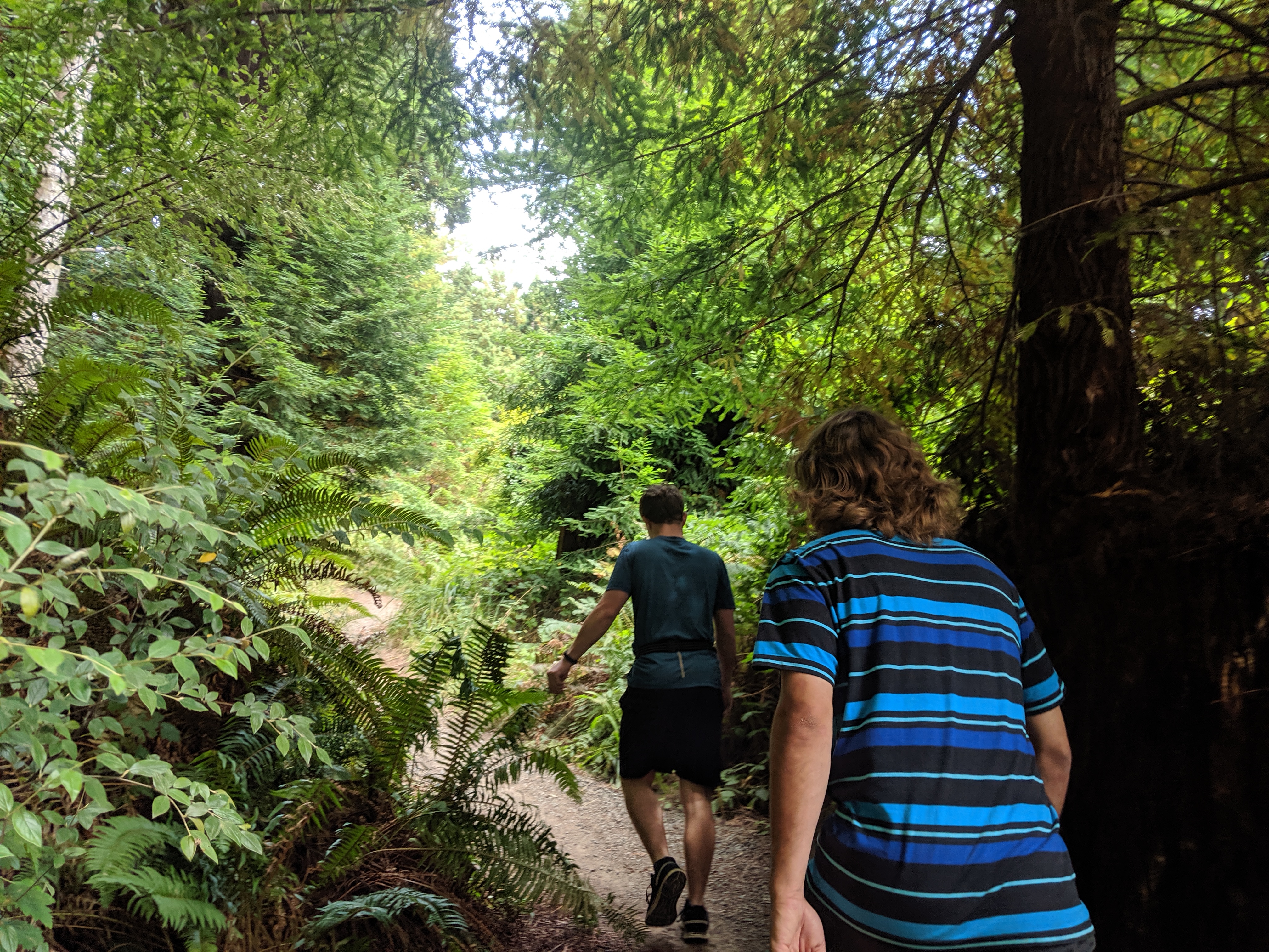
    A network of trails connects the different points of interest spread throughout the park. Plan to hike at least a couple of miles if you want to see everything. Most of the main rim trail is fairly flat and some sections are wheelchair-accessible. However, the access trails that take you to most of the prominent locations are very steep, as they often run straight up and down the steep coastal hills.

    Wedding Rock is the most spectacular point in the park. This massive rock structure juts up from the coastline, providing stellar views of the surrounding rough coastline. The park’s original caretaker was married there in the early 1900s, and Wedding Rock has been home to several weddings every year since.

    Sumeg Village is a recreated Yurok village, built by the local tribe with modern tools and traditional materials and practices. The village is used by the tribe for cultural traditions and features two redwood canoes, a sweat room and a native plant garden, also maintained by the tribe.

    Sumeg Village provides a nice spot for quiet reflection. The area was built with traditional Yurok techniques by the local tribe, and is still used today for rituals and ceremonies. | Photo by Jett Williams

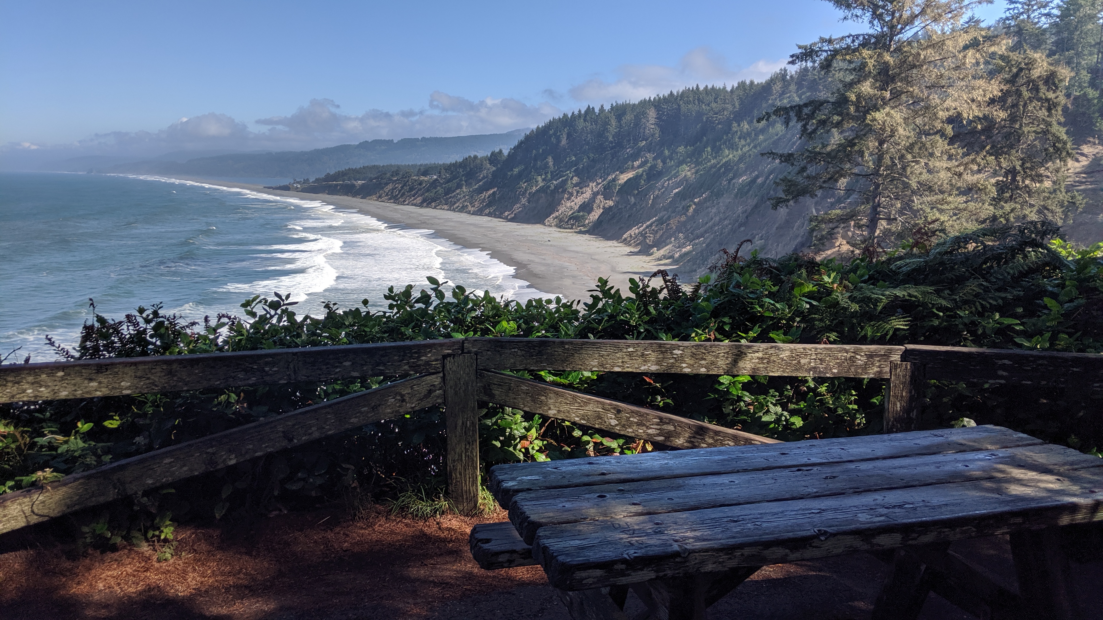
    The Agate Beach is another location worth your time. This expansive stretch of coastline seems to span as far as the eye can see, with a pristine beach of light sand and naturally-occurring agate stones.

    When visiting Patrick’s Point, remember that swimming in the frigid North Coast waters is highly discouraged. The undertow is strong, and sweeper waves can catch unattentive visitors off-guard. Dogs are allowed, on-leash only, but are not permitted on trails or beaches. Also, refrain from picking the local mushrooms and wildflowers. They have a hard enough time surviving without being plucked by the unaware.

    After a long school week, we all need a bit of calm reflection and relaxation. Carve out at least an afternoon later this week or this weekend to visit our closest state park, and don’t forget to keep exploring!

  • #ExploreHumboldt: The Arcata Community Forest

    #ExploreHumboldt: The Arcata Community Forest

    Forest bathing can be the cure to the daily hustle and bustle of student life

    Humboldt’s natural areas are world-class, but many students don’t take full advantage of the resources that surround us. Between classes, homework, employment, friends, clubs, housing and family (are you stressed yet?) it can be hard to find time to wander around in the woods.

    This column will provide information on my favorite natural areas to visit around Humboldt County. There’s so much to see and with such a low barrier for entry, I feel like more people should be getting out there.

    Humboldt is home to many creatures large and small. This Coastal Giant Salamander was found posing in the middle of a trail. Watch your step! | Photo by Jett Williams

    Opening your senses to a natural environment is a process called forest bathing, and has been proven to slow heart rates and decrease depression and anxiety.

    In the coming months, classroom life and elongated periods of sitting will become the new norm, making any opportunity to go out and stretch our legs extremely valuable.

    Most of us are transfers, as only 15 percent of the student body is from this area. I’m one of the 85 percent, having moved here from the Bay last summer. When I first arrived in Arcata, it took me a while to get out of my shell and start exploring.

    After a year up here, I’m still finding new spots to check out. The natural areas are so dense and varied, you never run out of things to do.

    Deeper in the Arcata Community Forest is Trail 13. One of the standout features of this bike-centered trail is a massive burned log you walk or ride through. | Photo by Jett Williams

    For newcomers, some of these spots might seem intimidating or unattractive. We’ve all seen “Murder Mountain,” and heard the stories about Humboldt County’s missing person rate. But these sensationalized tales do little to reflect the true nature of the area we now call home.

    The truth is, exploring Humboldt is as safe as exploring anywhere else. A multitude of dark forests and narrow roads give the illusion of being miles from nowhere, but there’s tons to explore within a short drive, bike or bus ride, or even a walk.

    Because this is the first week of school and we’re still getting settled into our routines, we’ll start with something close and easy: The Arcata Community Forest.

    The Arcata Community Forest’s map looks dense and confusing, but the forest becomes more intuitively navigated the more time you spend under its dense canopy.

    This is the most accessible area for the majority of HSU students, as it starts right where the East side of campus ends. A 10-minute walk from anywhere on campus and you’re surrounded by towering redwoods and bright green ferns and breathing humid forest air.

    Some majors like Forestry use the ACF as a place to get hands-on training and experience. But students are never required to walk the gravel roads and twisting trails that crisscross the forest’s 790 acres.

    Some parts of the ACF have limited cell service, so I recommend downloading Avenza PDF Maps. This app is recommended by the City of Arcata and allows you to download free maps of the local parks. These maps provide you with accurate trail info without relying on a cell signal and are a valuable asset to keep you from getting lost.

    Because of its proximity to campus, one of the best ways to experience the ACF is by working it into your weekly schedule. The lower section of the ACF offers a small network of interlaced multi-use trails perfect for a quick walk before or after class. Fill your mid-day gap by taking the access trail from the corner of Union and 14th up to Redwood Park for a picnic lunch!

    The terrain of the Arcata Community Forest is unique and varied, and tight single track often gives way to vast open views. | Photo by Jett Williams

    More ambitious explorers can climb to the upper regions of the park for a more private experience, but solitude comes with a cost. The coastal mountains gain elevation quickly and will leave you feeling equal parts sore and satisfied.

    It’s all worth it, as some of the park’s most scenic trails can be found in the remote Western regions. Road 14, a gated gravel road which starts off of Granite Ave., takes you along the Jolly Giant creek up to a scenic picnic table on the site of the former Jolly Giant Reservoir. From there, you have a multitude of options to extend your route, create loops back to campus or return the way you came.

    The ACF is a valuable source of solitude and stress relief for HSU Students, as it couldn’t be any closer to campus. Use this resource to your advantage, and don’t forget to tag #ExploreHumboldt on your next adventure.