The Lumberjack


Students Serving The Cal Poly Humboldt Campus and Community Since 1929

Tag: Jett williams

  • The Lumberjack Takes Home 14 Media Awards

    The Lumberjack Takes Home 14 Media Awards

    Humboldt State student newspaper wins four first place California College Media Association awards

    The Lumberjack won 14 California College Media Association Excellence in Student Media awards for a variety of work in 2019. The Lumberjack took home four first place awards, seven second place awards and three third place awards at the CCMA awards banquet Feb. 29 in San Francisco.

    Deija Zavala won Best Photo Series, Phoebe Hughes won Best Cartoon Illustration, Megan Bender won Best Illustration and Chelsea Wood won Best Non-News Video.

    Megan Bender took second in Best Newspaper Front Page Design and Best Photo Illustration, Jose Herrera took second in Best Arts and Entertainment Story, Jett Williams took second in Best Newspaper Column, Liam Warner took second in Best Sports Story and Thomas Lal took second in Best News Photograph. James Wilde, Chelsea Wood and Collin Slavey took second in Best News Video.

    Freddy Brewster came third in Best Headline Portfolio for three different headlines and third in Best Breaking News Story, while Tony Wallin took third in Best Feature Story.
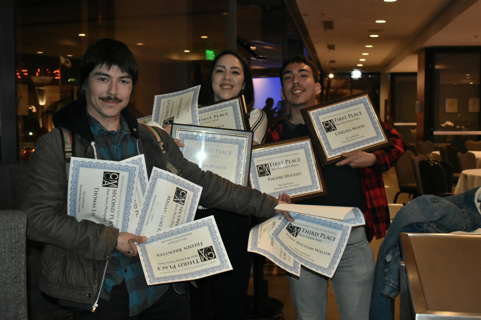
    HSU’s bilingual, monthly student-run newspaper, El Leñador, won 12 awards, including three first place awards. HSU’s student-run semesterly magazine, Osprey, won three awards, with a first place award to Megan Bender for Best Magazine Inside Page/Spread Design.

    The Lumberjack is the independent, student-run online media publication and newspaper established in 1929 at Humboldt State University.


    View the full list of HSU student award winners below:

    CCMA Winners 2020:
    FIRST PLACEPUBLICATIONSTUDENT(S)
    Best Photo SeriesThe LumberjackDeija Zavala
    Best Editorial CartoonThe LumberjackPhoebe Hughes
    Best IllustrationThe LumberjackMegan Bender
    Best Non-News VideoThe LumberjackChelsea Wood
    Best Newspaper Inside Page/Spread DesignEl Leñador Celeste Alvarez, Jose Herrera
    Best Newspaper Front Page DesignEl Leñador Kylee Conriquez, Jose Herrera
    Best Non-Breaking News StoryEl Leñador Jose Herrera
    Best Magazine Inside Page/Spread DesignOspreyMegan Bender
    SECOND PLACE
    Best Newspaper Front Page DesignThe LumberjackMegan Bender
    Best Arts and Entertainment StoryThe LumberjackJose Herrera
    Best Photo IllustrationThe LumberjackMegan Bender
    Best News VideoThe LumberjackJames Wilde, Chelsea Wood, Collin Slavey
    Best Newspaper ColumnThe LumberjackJett Williams
    Best Sports StoryThe LumberjackLiam Warner
    Best News PhotographThe LumberjackThomas Lal
    Best IllustrationEl LeñadorKylee Conriquez
    Best EditorialEl LeñadorBrenda Estrella
    Best Special Issue/SectionEl LeñadorJose Herrera, Vanessa Flores
    Best Overall Newspaper DesignEl LeñadorJose Herrera, Celeste Alvarez, Cara Peters, Ash Ramirez
    Best Social Media ReportingEl LeñadorVanessa Flores
    Best Magazine Cover DesignOspreyMegan Bender
    THIRD PLACE
    Best Headline PortfolioThe LumberjackFreddy Brewster
    Best Feature StoryThe LumberjackTony William Wallin
    Best Breaking News StoryThe LumberjackFreddy Brewster
    Best NewspaperEl LeñadorStaff
    Best Interactive GraphicEl LeñadorCeleste Alvarez
    Best InfographicEl LeñadorCara Peters
    Best Arts and Entertainment StoryEl LeñadorLora Neshovska
    Best Magazine Photo SeriesOspreyJett Williams, Megan Bender
  • #ExploreHumboldt: Fern Canyon

    #ExploreHumboldt: Fern Canyon

    Fern Canyon provides a beautiful, classic Humboldt scene with a stunning beach as a bonus

    Hello and welcome back to the #ExploreHumboldt column, where we take an in-depth look at nearby natural areas that Humboldt State students should make a point of visiting. This week, we’re looking at one of the most heavily-photographed locations in Humboldt County: Fern Canyon.

    Seriously, if you search “#HumboldtCounty” on Instagram it’s roughly 30 percent Fern Canyon photos, the rest being a mix of close-up weed shots and photos of the beach.

    Fern Canyon is in Prairie Creek State Park and is part of a much larger network of coastal trails. You could spend multiple days getting lost in the 75 miles of trails or camping at the 75 sites. There’s also a 19-mile mountain bike loop for those who are interested.

    The towering walls of Fern Canyon are so picturesque, they were actually used in several parts of Steven Spielberg’s classic “Jurassic Park” franchise. | Photo by Jett Williams

    Fern Canyon is exactly what it sounds like, a big natural canyon with 50-foot walls completely coated in five different types of ferns. Fern Canyon trail runs through the base of the canyon, but the trail is really more of a suggestion. Once you’re in the canyon, hiking seems almost irrelevant and you’ll want to stop plenty of times to soak in the views.

    The cool coastal air combined with the sound of the stream running through the canyon’s floor makes this an amazing spot for quiet relaxation and reflection. This stream also makes it very hard to navigate the canyon floor without getting your feet wet, so wear waterproof shoes if you’ve got them. Direct sunlight only reaches the canyon for a few hours each day, so bring an extra layer to avoid getting cold in the later hours of the day.

    To reach Fern Canyon you’ll need a car. The turn off 101 is two miles north of Orick and a 40-minute drive from Arcata. After the turn onto Davison Road, continue for three and a half miles until you reach the state park entrance. Be aware that it’s $8 per vehicle, and they DO NOT accept credit cards. The closest ATM is Orick, so plan accordingly.

    The final miles of dirt road to reach the trailhead are littered with potholes, and a stream crossing in the last mile is where less capable vehicles will have to park. Luckily, it’s a short hike from there to the trailhead, but anything with decent clearance can make it through.

    Fern Canyon, like Strawberry Rock, is a very popular destination without a whole lot of square footage. This means that unless you arrive very early or very late, you will not be alone. When I visited, the parking lot was almost full. However, the park is expansive and visitors can explore at their own pace, so while Fern Canyon is never empty, I never felt crowded or like I needed more space.

    Roosevelt Elk are a common sight to see in this state park, but keep your wits about you. Elk can become aggressive in an instant if they’re provoked. Keep a safe distance and use the zoom on your camera. | Photo by Jett Williams

    After you’ve finished exploring the canyon, walk through the parking lot, past the bathrooms and out onto the expansive beach. Miles of flat sand stretch out in either direction, providing a stark contrast to the confined canyon walls. If you’re lucky, you might come across a herd of wild Roosevelt Elk in the coastal grass fields just inland of the beachfront.

    These creatures have a six-week mating season from August to October and are aggressively protective of their young. Never directly approach or get too close to the Elk, as they can turn confrontational in a heartbeat.

    Detailed maps are available at the entrance booth or online at the park’s website. Ambitious explorers can link the Fern Canyon loop into other optional trails, and turn a short excursion into a full day hike. Either way, get out there and don’t forget to #ExploreHumboldt.

  • Danny Brown: U Know What I’m Sayin?

    Danny Brown: U Know What I’m Sayin?

    uknowhatimsayin¿ stylizes manic energy and strives for greatness

    The last time we heard a full-length project from Danny Brown, it was 2016’s spiraling ode to excess and insanity, “Atrocity Exhibition.” The album used off-the-wall production, manic vocal inflections and harrowing subject matter to paint Brown’s life as a descent into chaos.

    Now with 2019’s “uknowhatimsayin¿,” Brown leaves the coked-up, hyperactive energy of his last project behind and replaces it with motivational tracks focused around striving for your goals and never giving up. Of course, there’s still a healthy dose of bizarre punchlines, drug and sex-related content and enough eclectic beat choices to leave your head spinning after a full listen.

    The introductory “Change Up,” lays out the thematic groundwork of the album. Organs, synths and a steady, understated drumbeat flesh out the track as Brown laments, “Up all night, toss and turn when I sleep; Pacing around, drowning sorrows in my drink; Can’t even think, got my mind wrapped up; But I still bite down, clench my teeth, knuckle up.”

    Resiliency is a common theme in Brown’s projects, but this album embraces self-reliance and motivation as the central theme of the work. Rather than basking in the highs and lows of overindulgence and addiction like previous works, Brown finds a nice middle ground where he acknowledges the darker moments of his life while committing to forward motion.

    The best example of this is on an early single for the project, called “Best Life.” The tracks verses detail Brown’s origin as a dope dealer, but pairs an uplifting chorus about living your best life now, because it’s the only one you’ve got.

    This cut is followed in the tracklist by the title song, which has Brown spitting life lessons and motivational advice, with the refrain, “Know what I’m sayin’?” A chorus from Obongjayar and smooth, jazzy drums contribute to the uplifting vibe of this song.

    One of the hallmarks of a Danny Brown project is wildly creative wordplay, and this album delivers that in spades. Brown sums up his writing style succinctly on the track “Savage Nomad,” which features looped electric guitar over a thumping beat. “It’s quite simple, I’m mental, all over instrumentals; Detrimental to health, lyrics is quintessential,” Brown spits.

    Brown is no stranger to bizarre instrumentals, but the beats on this project deserve special praise. From the spacey, reverbed A$AP Ferg adlibs on “Theme Song” to the hectic basslines of “Negro Spiritual” and the atmospheric, synthed-out breathing on “Belly of the Beast,” the album provides a wide range of vibes and moods that have been lacking from the current rap climate with its affinity for loud, hi-hat-heavy trap production.

    Features from Run The Jewels, JPEGMafia, Obongjayar and Blood Orange are sprinkled throughout the album to provide variety. Special praise must be lauded to Killer Mike of RTJ, who comes through with some of his coldest bars to date in the song, “3 Tearz.” “I sip on fine wines, fine dine with dimes and nines; I got an Einstein mind and I still tote iron; I’m a P-I-M-P in my own rhyme; Space-age gorilla pimpin’ out the cage with mine.”

    If there’s one thing missing from this new album, it’s the staggering emotional highs and lows felt on “Atrocity Exhibition.” Because this new project is more laid-back, it never reaches these heights. Regardless, “uknowhatimsayin¿” is confirmation of Brown’s place as one of the most creative and consistent rappers working today.

  • #ExploreHumboldt: Arcata Marsh

    #ExploreHumboldt: Arcata Marsh

    Try and lose yourself in the Arcata Marsh for the best experience

    Welcome back to the #ExploreHumboldt column, your source for accessible natural areas to visit in your spare time. This week, we’ll look at a unique, double-duty location that serves as a wastewater treatment facility and a beautiful habitat for countless bird species: the Arcata Marsh!

    This 307-acre sanctuary is located in southern Arcata, and can be accessed from South G and I streets. This places the marsh within a 15-minute walk or a five-minute bike ride from campus.

    The Marsh’s interpretive center provides information on the wide variety of bird species that frequent the marsh, and how the marsh filters Arcata’s wastewater into clean water that can be released back into the bay. | Photo by Jett Williams

    Any trip to the Marsh should start at the Interpretive Center. There, you’ll find installations detailing the many exotic bird species that stop at the marsh on their migratory journeys up and down the coast. So far, over 300 unique bird species have been spotted in the marsh this year. Some of these are extremely rare, or are typically found on the East Coast.

    From the Interpretive Center, multiple trails spiderweb out to every corner of the park. In total, there are about 5.4 miles of mostly gravel trail, with some paved sections. Strategically-placed maps ensure that you won’t get lost and provide interesting information on the park’s science and history.

    But, as with any natural area, the best way to get a lay of the land is to get lost. Around every corner is another table or bench overlooking a scenic view, or an enclosed shelter for birdwatchers to observe the local wildlife.

    Organized nature walks are a good way to experience the marsh in a social environment, with experienced birdwatchers who can point out and identify rare bird species. | Photo by Jett Williams

    If you want a recommended route to get started, begin at the Interpretive Center and head north along the west side of Butcher Slough Log Pond. Turn left and follow the trail as it winds around Brackish Pond.

    This time of year, Brackish Pond is covered in a layer of green algae that gives it a surreal look and is a hotspot for birds. Stop at the bird viewing station on the northwest corner before heading south past Gearheart Marsh, and looping back to the Interpretive Center.

    In addition to being a nearby natural spot to get out to for some nature time, the Arcata Marsh serves as a wastewater treatment plant. Algae and bacteria help to purify the water as it moves through the different ponds of the marsh.

    One can spend hours wandering the marsh, checking out the different ponds and looking for exotic bird species. The marsh is expansive and rarely crowded, offering ample opportunities for seclusion. | Photo by Jett Williams

    Eventually, the water is sterilized with chlorine and flows back into the Humboldt Bay. This system allows Arcata to manage its wastewater production while providing a refuge for local wildlife and a local park for residents to enjoy.

    If you’d like to check out the Arcata Marsh with the help of experienced and knowledgable guides, there are several guided marsh walks available. Friends of the Arcata Marsh meets every Saturday at 2:00 p.m. at the Interpretive Center for a guided marsh walk.

    For those looking to learn more about the many bird species that call the marsh a temporary home, the Redwood Region Audubon Society meets for guided birding walks every Saturday at 8:30 a.m. This walk meets at the I street parking lot.

    The Arcata Marsh is an amazing free resource for students in need of a quiet oceanside spot to explore and relax in. Get it while you can, and don’t forget to #ExploreHumboldt!

  • Mountain Biking Has a Sustainability Problem

    Mountain Biking Has a Sustainability Problem

    With all the gear and gadgets, mountain biking isn’t as sustainable as it may seem

    For a sport that usually occurs in natural settings, and whose participants generally value the ecosystem and the world around us, mountain biking has a serious sustainability problem.

    Everything has an expiration date. No matter the maintenance, nothing is ever ‘for life,’ and nowhere is this truer than in the mountain bike industry. Chains stretch, tires bald or blow out, brake pads get worn down and bearings become crunchy and rough.

    Issues arise when one attempts to revive or service a bike. Many of the functions are delicate and precise, requiring fresh parts to operate smoothly. This means something as simple as a tune-up often results in cables, housing, tubes and tires being thrown away.

    Improper installation or use means that these parts break before they should and get replaced prematurely. Some people replace prematurely simply because they want improved performance.

    It’s hard to process this waste on an individual level, but walk into your local bike shop and look in the trash cans. Often, they’re filled with very un-recyclable items that are used, removed and replaced.

    Of course, the nature of the sport is that parts get worn down or broken and must be swapped. That so many of these parts get replaced prematurely or destroyed early due to user error is only part of the problem.

    With the way our world is headed, mountain biking is due for a rude awakening on the ways that it creates unnecessary waste.

    Other issues arise when we look at the bike industry and the way they market their high-end products. Often, these brands will swaddle their expensive parts in multiple layers of processed cardboard and plastics.

    Recently, I purchased a new shifter for my bike. The shifter is a small plastic pod, about the size of a mandarin orange. It arrived in a box that I could’ve fit my shoes into.

    Just because you can get away with selling drivetrain parts that cost as much as high-end electronics, doesn’t mean you need to package them like iPhones.

    If these parts were packaged in plastic bags rather than bulky cardboard, you could fit 10 times the items in a similar space, drastically cutting down on shipping material and resources.

    Usually, I give corporations a bit of lee-way with the way they package expensive items. It makes sense that they’d want to provide the customer with a sense of exclusivity for choosing to spend their hard-earned dollars on these parts. But with the news about our world’s climate becoming grimmer with every passing day, the mountain bike industry needs to step up and restructure their priorities to make the sport more sustainable.

    I’ve never met a mountain biker who didn’t care about the environment and the future of our planet. Unfortunately, when something breaks usually the whole bike is unrideable until the issue is corrected. Most of us just accept the impact of our sport as there aren’t many other options.

    With the way our world is headed, mountain biking is due for a rude awakening on the ways that it creates unnecessary waste.

  • #ExploreHumboldt: Hammond Trail and the North Coast

    #ExploreHumboldt: Hammond Trail and the North Coast

    Hammond Trail and Scenic Drive offer numerous natural areas to visit

    Hello and welcome to the #ExploreHumboldt column, the HSU student source for the most stunningly scenic natural areas close by. For this week’s column, I’m doing something a little different.

    Instead of giving you one condensed area to check out, I’ll be going over some of my favorite spots along the stretch of coastline just north of here. This article barely scratches the surface of what’s out there, so as always use this as a guide for your own adventures.

    The Hammond Trail starts at the Mad River Bridge in the Arcata bottoms. | Photo by Jett Williams

    It all starts with the Hammond Trail. This 5.5-mile, mostly paved line follows the coast up from the Arcata bottoms to Clam Beach, just north of McKinleyville. To get there, take Janes Road to Upper Bay Road, and turn right onto Mad River Road. Follow this until you come to the trailhead.

    Hammond Trail starts at an old footbridge spanning the Mad River, decorated with typical Humboldt graffiti and a series of padlocks attached to the rusty chain-link fence. The trail was voted “Best Place to Walk, Jog or Bike” in a Times-Standard poll, and alternates between roads and paved pedestrian trail as you make your way through McKinleyville.

    The Mad River bridge has several padlocks, ranging from rusty and old to fresh, dangling from its chain links. | Photo by Jett Williams

    After meandering along for roughly 5 miles, you will make your way to Clam Beach County Park. This spot offers sandy beach access, paid camping spots and scenic picnic tables with BBQ pits. A solid destination for a weekend excursion, or a nice rest spot during a run or bike ride, but the best locations are still further north.

    Unfortunately, this is as far as the Hammond Trail goes. To get to the real goods along the aptly-named Scenic Drive, you can take your vehicle of choice onto the freeway at the end of Clam Beach Drive, then take the first exit for Westhaven Drive. Turn left, then right to continue north on Scenic.

    The Hammond Trail has an optional section for hikers only that traces the local watershed, and provides a quieter hiking option. | Photo by Jett Williams

    If you’re on foot or don’t feel like biking on 101, it’s probably better to park in Clam Beach, walk the trail, then come back and drive to Scenic. There are plenty of places to park once you reach the road. Alternatively, you could park in Trinidad and ride a bike down the road from there.

    It should be noted that taking a bike on the freeway carries a whole host of extra risks, and should not be done frivolously. Wear bright colors and use a daytime taillight to ensure that you’re seen by motorists, never take longer on the freeway than you absolutely have to and don’t forget your helmet!

    Multiple footbridges like this one can be found along the Hammond Trail. | Photo by Jett Williams

    Scenic Drive is aptly named, and first-timers will find it difficult to keep their eyes on the road as they’re treated to vista after vista of rugged northern coastline. But sections of the road turn unexpectedly to gravel and it becomes single-lane in a few areas, so it’s best to keep your wits about you.

    Around every corner are turnouts and parking lots for the many beaches and access points along the road. One of my personal favorites is Baker Beach. This secluded beach is dotted with monstrous coastal boulders, scalable at low tide but inaccessible when the waves roll in. Baker Beach is also clothing-optional, but you won’t get kicked out if you prefer to keep it in your pants.

    Baker Beach provides scenic seclusion. During low tide, one can climb the rocks in the center frame. | Photo by Jett Williams

    Near this beach are two of my favorite spots, a hidden swing that looks to the southern coast, and a treehouse platform with two chairs that looks to the north with mind-blowing views of Trinidad Head. Not all spots are for everyone, so I’ll leave the details of the exact location up to you to find. If you get out to the beach, finding these locations is fairly straightforward as long as you look around.

    After Baker Beach, it’s a short jaunt along Scenic Drive to get to Trinidad. While you’re there, check out The Lighthouse Grill. I recommend the Mashed Potato Cone (a Lighthouse Grill staple) and the Jalapeño Jelly Burger (an acquired taste).

    The access trail to Baker Beach is clearly not handicapped-accessible. | Photo by Jett Williams

    The best thing about this stretch of coastline is its different options. You can park in Trinidad and bike south along Scenic, park at Clam Beach and jog or walk south or leave from Arcata and ride the whole thing.

    Whatever you decide, the point is to do something. Make these days count, as soon we’ll be trapped under an oppressive sheet of rain. Find some time, and don’t forget to #ExploreHumboldt.

  • #ExploreHumboldt: Patrick’s Point

    #ExploreHumboldt: Patrick’s Point

    Patrick’s Point offers multiple options for beach-lovers at an affordable price

    This week’s #ExploreHumboldt column covers a fan favorite, the majestic and expansive Patrick’s Point. This one-square-mile State Park features some of the best beach spots around and is a perfect destination for a daytime picnic, sunset beach run or weekend camping trip.

    As a state park, Patrick’s Point includes amenities that we have not seen in previous #ExploreHumboldt entries. These include bathrooms with running water, clearly marked trailheads with accurate mileage, picnic tables with BBQ grills and over 120 overnight camping spots.

    Because of its State Park status, Patrick’s Point has well-maintained and clearly-marked trails with mileage indicators. | Photo by Jett Williams

    However, these benefits come at a cost. There is a $8 vehicle fee, with no student discount. The litany of areas to explore and the overall quality of the experience make it worth the price of admission. You should leave a couple hours of time minimum to to fully experience the park and get your money’s worth.

    Patrick’s Point also features several “Hike n’ Bike” campsites. Those who bike or hike into the park benefit from free admission as well as their own area with campsites reserved for non-car users. These sites include all the features of a car site, with a location closer to the best points of interest.

    The view looking north from Wedding Rock is one of the most spectacular in the park. The beach access trail can be seen in the bottom left corner. | Photo by Jett Williams

    To get to Patrick’s Point, take Hwy 101 north past Trinidad, and take the ‘Patrick’s Point’ exit. Turn left, and continue until you see signs for the park. Alternatively, you can drive to Trinidad and bike along Stagecoach Road, turning left onto Patrick’s Point drive before arriving at the park. This way, you get a bit of extra exploration in, while avoiding the $8 vehicle fee.

    If you want to see everything, it’s worth bringing some hiking shoes and a day pack to walk the length of the park. There are a ton of different spots to visit at Patrick’s Point, so I’ll quickly go over some of my favorites.

    Sea Anemones are easily found at the tidepools near Palmer’s Point during low tide. Tide tables are available online and at the park’s entrance. | Photo by Jett Williams

    A network of trails connects the different points of interest spread throughout the park. Plan to hike at least a couple of miles if you want to see everything. Most of the main rim trail is fairly flat and some sections are wheelchair-accessible. However, the access trails that take you to most of the prominent locations are very steep, as they often run straight up and down the steep coastal hills.

    Wedding Rock is the most spectacular point in the park. This massive rock structure juts up from the coastline, providing stellar views of the surrounding rough coastline. The park’s original caretaker was married there in the early 1900s, and Wedding Rock has been home to several weddings every year since.

    Sumeg Village is a recreated Yurok village, built by the local tribe with modern tools and traditional materials and practices. The village is used by the tribe for cultural traditions and features two redwood canoes, a sweat room and a native plant garden, also maintained by the tribe.

    Sumeg Village provides a nice spot for quiet reflection. The area was built with traditional Yurok techniques by the local tribe, and is still used today for rituals and ceremonies. | Photo by Jett Williams

    The Agate Beach is another location worth your time. This expansive stretch of coastline seems to span as far as the eye can see, with a pristine beach of light sand and naturally-occurring agate stones.

    When visiting Patrick’s Point, remember that swimming in the frigid North Coast waters is highly discouraged. The undertow is strong, and sweeper waves can catch unattentive visitors off-guard. Dogs are allowed, on-leash only, but are not permitted on trails or beaches. Also, refrain from picking the local mushrooms and wildflowers. They have a hard enough time surviving without being plucked by the unaware.

    After a long school week, we all need a bit of calm reflection and relaxation. Carve out at least an afternoon later this week or this weekend to visit our closest state park, and don’t forget to keep exploring!

  • #ExploreHumboldt: Strawberry Rock

    #ExploreHumboldt: Strawberry Rock

    Killer views? Rock climbing? Questionable legality? This trail has it all!

    Welcome back to the #ExploreHumboldt column, where I give you the low-down on the most accessible natural locations for HSU students to visit when they need a healthy way to relax.

    Last time, we looked at the option closest to campus, the Arcata Community Forest. Now that we’ve settled into our new schedules, I’ll be suggesting a hike that some of you may already be familiar with: Strawberry Rock!

    This three-mile out-and-back is a very popular local destination with a short but somewhat strenuous hike and gorgeous panorama views at the namesake summit.

    To get to Strawberry Rock from Arcata, drive North on 101 until you reach the Trinidad exit, number 728. Go straight at the stop sign and continue until you reach the end of Trinidad Frontage Road.

    The trailhead parking lot can get crowded, so try to arrive in the early or late hours of the day. | Photo by Jett Williams

    Park anywhere in the cul-de-sac and look for the gate covered in stickers and graffiti. This is the trail head.

    Alternatively you can take the bus (free for HSU students) up to Trinidad, then it’s an additional mile’s walk from the bus stop to the trail head.

    The hike starts close to the freeway, but you are soon enveloped in the classic green curtains that characterize many of Humboldt’s best trails. This particular line is built on Green Diamond logging land and follows an old access road for most of its length.

    Soon after you start the hike the trail begins to steepen and split into several optional lines. Most of these lead back to the main trail but use your best judgment when exploring. Luckily, you keep a good cell signal for the entirety of the hike.

    These helpful arrows lead you to the final section of the trail. | Photo by Jett Williams

    The main trail is marked with a series of makeshift arrows, built out of fallen logs and rocks by considerate trail users. These ensure that first-timers don’t get confused at the multiple splits.

    If you’re especially worried about getting lost, there are maps of the full hike available at singletracks.com.

    About a mile into the hike, look for a muddy spot with a long bent log spanning the right side of the trail. Look up to see the platforms used by activists who camped high in the trees to protest Green Diamond’s logging operations. A banner is also visible with a call to “Stop Clearcutting.”

    Currently, Green Diamond is in an agreement with the Trinidad Coastal Land Trust to not log while the Trust attempts to fundraise.

    These rock formations are built by the many visitors to this beautiful area, and are constantly changing. | Photo by Jett Williams

    If they can raise enough money to buy the land from Green Diamond, the Trust will be able to keep this gem open for future generations. If not, Green Diamond is looking at logging several tracts of land near the trail, according to the TCLT website.

    In the last third of the climb, you’ll come across a wide-open quarry area. From here, the trail takes you through several rock designs laid onto the gravel before following an established road to the final climb.

    The ‘crux’ of this hike comes at the end, where explorers will have to use a rope to scale an exposed rock wall. If you’ve made it this far, you can probably handle this last bit of exertion. There are views below this point, but climbing the rope is the only way to get the full experience.

    The final push of the hike is this intimidating boulder scramble. A rope is attached to make things easier, but it’s actually much less challenging then it seems. | Photo by Jett Williams

    When you’ve made it to the rock, be careful! The edges are cliff faces and you have to use your best judgment while maneuvering around.

    Come prepared with extra water and snacks as you’ll want to relax and soak in the views for a while when you reach the top. On clear days (the only days worth visiting!) you can see Trinidad Head to the west and far beyond Eureka to the south.

    After you’ve had your fill, enjoy the downhill hike back. The trail is usually muddy and rooty, so the best shoes for the hike are both sturdy and dirty.

    This trail is a perfect place to get a good walk in while experiencing some truly dank Humboldt forests. It’s also a good spot for anyone wanting to do some light bolder-scrambling and climbing without having to invest in expensive shoes or harnesses.

    Early birds and latecomers will get the best experience, as this spot can get crowded during peak traffic hours. Get out there sometime between your busy schedules and don’t forget to #ExploreHumboldt!

  • #HowTo: Exploring with Center Activites

    #HowTo: Exploring with Center Activites

    HSU’s Center Activities helps students get out and around Humboldt County


    Trying to explore Humboldt but don’t have a paddle to go with your board? Center Activities is an on-campus resource available to students looking to get geared up and participate in local adventures.

    The staff at Center Activities are friendly and attentive and they’re more than happy to help students find what they need to enjoy their day out in Humboldt County. Adventure Program Director Deserie Donae says Center Activities makes an effort to ensure students feel welcome on campus and in the community.

    “We can outfit a student with anything but shoes,” Donae said. “We get people prepped and prepared to go out by providing food and transportation so people don’t have to think too hard about it. We want the outdoors to be easy and accessible.”

    The Lumberjack has compiled a convenient how-to playlist of videos to guide readers toward fun activities. This list is a great way to introduce students to an outdoor lifestyle in a healthy way.

  • #ExploreHumboldt: The Arcata Community Forest

    #ExploreHumboldt: The Arcata Community Forest

    Forest bathing can be the cure to the daily hustle and bustle of student life

    Humboldt’s natural areas are world-class, but many students don’t take full advantage of the resources that surround us. Between classes, homework, employment, friends, clubs, housing and family (are you stressed yet?) it can be hard to find time to wander around in the woods.

    This column will provide information on my favorite natural areas to visit around Humboldt County. There’s so much to see and with such a low barrier for entry, I feel like more people should be getting out there.

    Humboldt is home to many creatures large and small. This Coastal Giant Salamander was found posing in the middle of a trail. Watch your step! | Photo by Jett Williams

    Opening your senses to a natural environment is a process called forest bathing, and has been proven to slow heart rates and decrease depression and anxiety.

    In the coming months, classroom life and elongated periods of sitting will become the new norm, making any opportunity to go out and stretch our legs extremely valuable.

    Most of us are transfers, as only 15 percent of the student body is from this area. I’m one of the 85 percent, having moved here from the Bay last summer. When I first arrived in Arcata, it took me a while to get out of my shell and start exploring.

    After a year up here, I’m still finding new spots to check out. The natural areas are so dense and varied, you never run out of things to do.

    Deeper in the Arcata Community Forest is Trail 13. One of the standout features of this bike-centered trail is a massive burned log you walk or ride through. | Photo by Jett Williams

    For newcomers, some of these spots might seem intimidating or unattractive. We’ve all seen “Murder Mountain,” and heard the stories about Humboldt County’s missing person rate. But these sensationalized tales do little to reflect the true nature of the area we now call home.

    The truth is, exploring Humboldt is as safe as exploring anywhere else. A multitude of dark forests and narrow roads give the illusion of being miles from nowhere, but there’s tons to explore within a short drive, bike or bus ride, or even a walk.

    Because this is the first week of school and we’re still getting settled into our routines, we’ll start with something close and easy: The Arcata Community Forest.

    The Arcata Community Forest’s map looks dense and confusing, but the forest becomes more intuitively navigated the more time you spend under its dense canopy.

    This is the most accessible area for the majority of HSU students, as it starts right where the East side of campus ends. A 10-minute walk from anywhere on campus and you’re surrounded by towering redwoods and bright green ferns and breathing humid forest air.

    Some majors like Forestry use the ACF as a place to get hands-on training and experience. But students are never required to walk the gravel roads and twisting trails that crisscross the forest’s 790 acres.

    Some parts of the ACF have limited cell service, so I recommend downloading Avenza PDF Maps. This app is recommended by the City of Arcata and allows you to download free maps of the local parks. These maps provide you with accurate trail info without relying on a cell signal and are a valuable asset to keep you from getting lost.

    Because of its proximity to campus, one of the best ways to experience the ACF is by working it into your weekly schedule. The lower section of the ACF offers a small network of interlaced multi-use trails perfect for a quick walk before or after class. Fill your mid-day gap by taking the access trail from the corner of Union and 14th up to Redwood Park for a picnic lunch!

    The terrain of the Arcata Community Forest is unique and varied, and tight single track often gives way to vast open views. | Photo by Jett Williams

    More ambitious explorers can climb to the upper regions of the park for a more private experience, but solitude comes with a cost. The coastal mountains gain elevation quickly and will leave you feeling equal parts sore and satisfied.

    It’s all worth it, as some of the park’s most scenic trails can be found in the remote Western regions. Road 14, a gated gravel road which starts off of Granite Ave., takes you along the Jolly Giant creek up to a scenic picnic table on the site of the former Jolly Giant Reservoir. From there, you have a multitude of options to extend your route, create loops back to campus or return the way you came.

    The ACF is a valuable source of solitude and stress relief for HSU Students, as it couldn’t be any closer to campus. Use this resource to your advantage, and don’t forget to tag #ExploreHumboldt on your next adventure.

  • Bike Month rolls in

    Bike Month rolls in

    Two-wheeled transportation celebrated all month with a range of bike-related events

    Cyclists, rejoice! May 1 officially ushered in Bike Month, an international holiday that Humboldt County takes very seriously. Events will be happening all month long and a variety of businesses have stepped up, offering discounts and special deals for those who arrive by pedal-power.

    Oona Smith is a member of the Bike Month Humboldt Coalition, an informal group of bike enthusiasts and advocates that helps curate the events and deals being offered. She was tabling at the Trails Summit held last weekend in the Kate Buchanan Room, and said to many participants that “every month is bike month.”

    “Our goal is to normalize biking as a convenient, fun and accessible form of transportation,” Smith said. “Not enough people use bikes for those short, one to three mile trips that are beyond a reasonable walking distance.”

    One event that Smith expects to have a large turnout is Arcata’s bike-to-work day which takes place on Thursday, May 9. All you have to do to participate is ride your bike to work, but early birds or those in need of bike maintenance will want to make it out to the Arcata Co-Op from 7-9 that morning. A pop-up station will be offering free breakfast snacks and coffee for riders and free tune-ups if your ride has been acting up recently.

    A similar event will be held at the Eureka Co-Op on Thursday, May 16. There will also be a rally at noon on May 6 where cyclists can congregate in the Arcata Plaza for food, fun and bike tune-ups courtesy of Revolution Bikes.

    A variety of bike-friendly-businesses are offering their own special deals and discounts to celebrate this month. Highlights include Los Bagels offering free coffee and Richards’ Goat Tavern and Tea Room offering 25 percent off your tab if you mention Bike Month, both of these deals available May 5-11.

    Other events like a bike film festival, kid’s bike rodeo and an array of morning “pancake” rides with a complimentary breakfast will be happening throughout the rest of the month. Details for these events can be found on the Bike Month Coalition website at bikemonthhumboldt.org.

    The other major component of National Bike Month is the National Bike Challenge. Participants can register at the Bike Month Coalition website and use a tracking app like Strava to track the miles they travel by bike over the course of the month. The team or individual who logs the most miles wins a litany of discounts and prizes from local businesses.

    Last year Humboldt riders were able to log over 31,000 miles in just this one month. Thanks to an especially quick start this year, Smith thinks that Humboldt cyclists can collectively track more than 35,000 miles before the end of the month.

    Smith thinks that commuting by bike is not just a fun way to stay fit, but a way to de-stress on the way to work. She thinks it’s important for the future of our planet.

    “Cars should be the exception, not the go-to. We can’t treat our planet that way,” Smith said. “Bikes bring a quality of life that many haven’t been exposed to. They’d be surprised at the joy and freedom of simply riding a bike.”