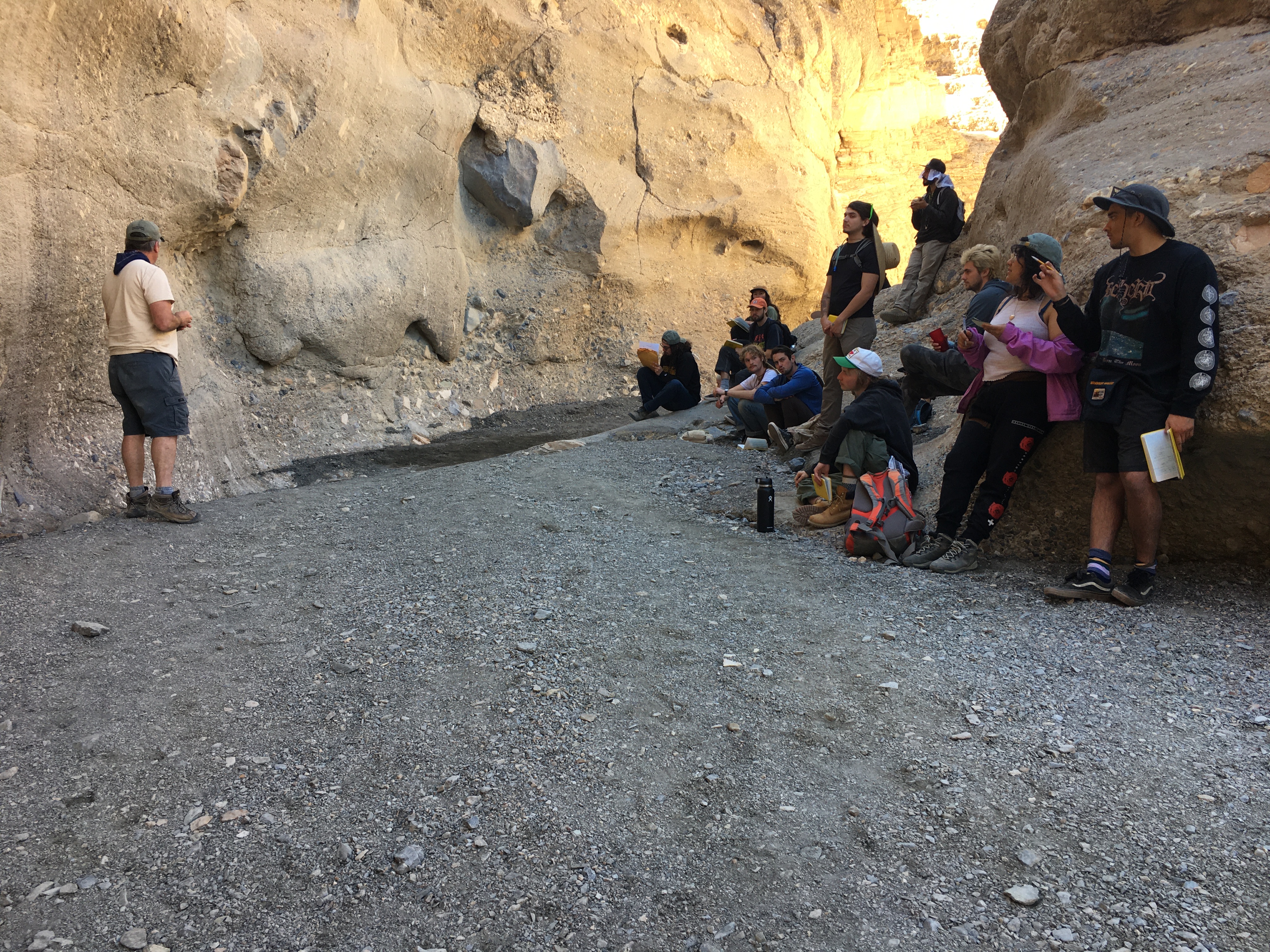
Since 2003, the CPH Geology department has been bringing students to various geologically significant sites across the western US during a marathon spring break field trip. This year marked the twentieth anniversary of Geology 110: Field Geology of the Western United States, uninterrupted by even the pandemic, and the retirement of veteran geology professor Mark Hemphill-Haley.
At 8am on March 11, all twenty members of the 2023 Geology 110 expedition met at Van Matre Hall weighed down with our camping gear to load into the four vehicles that would be our homes for the next two solid days as we drove to Death Valley.
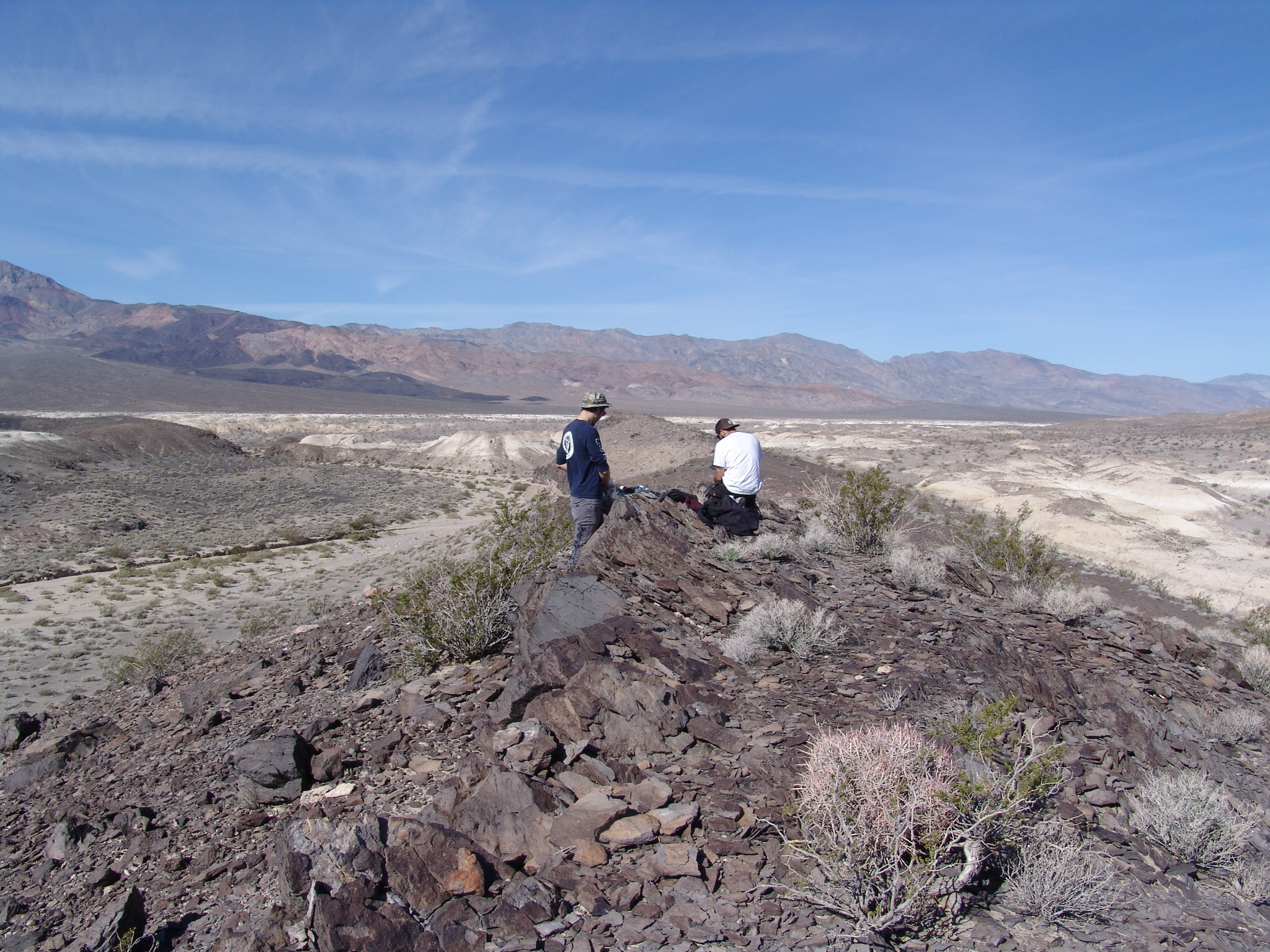
The Bonanza King Formation is a massive bed of carbonate rock that constitutes much of the boundary between Nevada and California. It is visible in many places across both states, but at Point of Rocks, it dominates the landscape. There, tilted beds of Bonanza King carbonate cut through the terrain like the ribs of a dead giant, draped in loose alluvium that slants down to the desert flats.
The footing on the ridge was treacherous. Skree slid under my feet as I moved up the slope, conscious only of the $500 Brunton Compass in the case at my belt and the possibility that I might drop it in front of everyone. I looked down, and, deciding that the bed at my feet was good enough, knelt to remove the Brunton from my belt case. In the protection of my big straw hat, I carefully lay the edge of the compass flush on the top of the carbonate bed, tilting it this way and that in a futile attempt to find the striking angle of the bed. It was exhilarating to finally be practicing a geology skill in the field. We were learning to measure the striking angle of a rock bed, which is the compass heading at which it cuts the ground, and I was determined to find it myself. In conjunction with the dip, which is the angle at which the bed descends into the ground, strike-dip measurements of rock beds and faults provide a picture of what’s going on under the surface. Finally, I set aside my pride and looked around to find Michelle Robinson, geology alum extraordinaire, who was down the ridge helping another student.
“Michelle, can you help me with this strike?” She smiled. Of course– this trip was all about learning. Each one of the students I spoke to about our experiences on the 2023 Death Valley trip said something similar.
“It was a little difficult to ask questions, but as soon as you understand that no one is judging you, it’s a perfect open environment,” third year geoscience student Jane Martinez said.
My experience was the same– at first, I felt in awe of the older students. They seemed to know exactly which questions to ask at each of the stops we made along the way, but I never felt too intimidated to ask my own questions. Every interaction was a reminder that science is not a competition, but a collaboration.
“At first, I was pretty shy too, but I just liked the fact that some of my upperclassmen helped me out with terms that I didn’t know and they were always giving me information on the simplest questions, and I really appreciated that,” said Daniel Abel, a third year geology major. “If I’m with someone new, I’m going to help them out as much as I can with the information that I have, so that they can get better and smarter with geology.”
This trip was an extremely valuable experience in that it allowed geology students to form bonds with their peers.
“I feel like I made a lot of really good friends over the trip and it’s kind of hard to do that sometimes,” Abel said. “I really appreciate that.”
Mark Hemphill-Haley has been associated with Humboldt’s geology department for decades, first as a student and then as a professor.
“The thing that excited me about geology when I first came to Humboldt was the enthusiasm that the department and the students shared about learning geology, and the depth of knowledge of the faculty and their excitement,” Hemphill-Haley said. “I think at Humboldt students in general are a little different than some other universities. You know, it’s a little harder to live here in some ways. So I feel like people that are here really want to get their life’s worth out of the programs. And so I just think that the students are special.”
Trips like Geology 110 and the connections made during those trips are what make Humboldt special. “The thing that I’ve noticed from when I was an undergrad to students now is, we’re still the same,” Hemphill-Haley said.
The Klamath salmon have been granted a reprieve. After decades of activism by Indigenous people, four of the six dams on the Klamath are finally coming down. Pacificorp, corporate owner of the dams slated for removal, was denied a renewal of their operating license by the Federal Energy Regulatory Commission in November of last year.
The Klamath Basin is one of the largest watersheds in the continental United States. Melting snow in Oregon’s Cascade Range mixes with runoff from Crater Lake, frigid waters flowing south and west to fill Klamath Lake. In past years, Klamath Lake’s cold, high-nutrient water tumbled to the coast, providing habitat for dozens of salmonid species.
Until the dams were built.
“They haven’t had any salmon in over 100 years,” said Regina Chichizola, director of Save California Salmon. “The Karuk Tribe no longer has spring salmon even for their spring salmon ceremonies.”
Salmonid populations in the Klamath Basin have seen a staggering 95% decline since Copco 1 was built in 1918 and those numbers only continued to fall as the basin was strangled by the next three dams. 400 miles of river habitat have been either partially or completely blocked to fish passage, and Klamath salmonids were on the path to extinction.
“Having that acknowledgement is a really big deal, because it’s not just acknowledging that this is a bad deal the river’s been given, but also us as well,” said Brook Thompson, restoration engineer for the Yurok tribe. “And that our voice does matter. Sometimes when you protest, in activism work, it feels like nothing’s gonna change and no one is hearing you, and that’s the case; it feels like we were finally heard.”
Thompson is a descendent of both Yurok and Karuk tribes, and a Ph.D. student.
There are currently four dams on the Klamath river. Copco 2 (1925) is slated for removal this year, followed by Copco 1 (1918), J.C. Boyle (1958), and Iron Gate (1964).
Photo courtesy of Regina Chichizola | Molli and son Chas smoke salmon over a firepit.
Negative impacts
The negative effects of the Klamath dams are numerous and interconnected. By slowing down the river, the dams allow the water to heat up in the sun.
“With that warm water, you get less dissolved oxygen, which the fish need to breathe,” said Thompson. “You get increased blue green algae blooms, which when they die, they take up dissolved oxygen, which, again, means less dissolved oxygen for the fish.”
The dams also cause the river to cut into the riverbed, by locking its flow into a narrow channel and preventing it from connecting to the wider floodplain.
On September 19th, 2002, dead Chinook salmon began washing up on the banks of the Klamath. During the next week, over 60,000 adult Chinook would wash up on the banks of the river like a rotting carpet.
“It was the day after one of the ceremonies,” said Thompson, who was present at the catastrophe as a child. “I was the same size as the salmon I saw the bodies of on the shore.”
This can be directly linked to the dams’ effects on the Klamath. The closely-packed conditions of the migrating Chinook and high water temperatures were a perfect environment for parasite Ichthyopthirius multifilis and bacteria Flavobacter columnare, which together ravaged the salmon population. Low flow from Iron Gate dam, due to irrigation runoff, was found to be a primary cause in the Fish Kill.
Indigenous sovereignty
The Yurok, Karuk, Hoopa, and Klamath tribes have been fighting for their rights to river governance and access for over a century.
“We’re fighting for our cultural sovereignty, making sure that we’re upholding our responsibility as human beings to make sure that we’re making this world a livable space for not just humans,” said Charley Reed, education director for Save California Salmon and descendent of the Yurok, Karuk, and Hoopa tribes.
Before colonization, Indigenous people depended on the Klamath as a primary source of food, with an average salmon intake of 450 pounds of fish per person per year. Today, that number has dropped to under a pound.
Activism
In 1973, Yurok community leader ‘Aawokw Raymond Mattz took the issue of Yurok fishing rights to the U.S. Supreme Court and won. However, state and federal agencies continued to crack down on Indigenous fishing well into the 1970s. This sparked a period of protest now called the Fish Wars. Anti-dam protests continued sporadically for decades, but gained renewed purpose after the 2002 Fish Kill, according to Reed.
“To get the U.S. to do things you have to sue them,” Thompson said. “That’s actually how we got the fishing rights back from my neighbor when I was a kid.”
In the 2000s, dam protesters spent one week of every month traveling to protest. Reed’s father was deeply involved with the movement for decades. Protest efforts in the wake of the Fish Kill led to the founding of Save California Salmon, a nonprofit organization founded, operated, and led by Indigenous people. SCS along with other groups focused the energies of the Klamath Tribal communities onto the dams. In 2004, dam owner Pacificorp filed to relicense the four dams on the Klamath. This provided an initial objective for the activists—stop the relicensing.
The activists took a multi-pronged approach to the campaign for the dams’ removal. They applied public pressure on lawmakers and dam owners, as well as working with state and federal officials.
Activists traveled to Scotland in 2004 to demonstrate against the parent company of Pacificorp, Scottish Power, during a shareholders meeting. In 2005, Scottish Power sold Pacificorp to Berkshire Hathaway and activists continued the pressure.
“2006 or 2007 was the first year we went to the Berkshire Hathaway shareholders meetings,” Chichizola said. “And even before that, we went to Pacificorp headquarters in Portland…. A big part of it was the community pressure for sure. Every step of the way, the community was there.”
In response to the continued activism, the Berkshire Hathaway board changed the rules of their Q&A sessions in 2008 to forbid questions about the Klamath dams.
Activists succeeded in lobbying the California and Oregon governments to require extensive renovations of the dams before they could be relicensed — a major victory. The Klamath Basin Restoration Agreement (KBRA) between the states would have demolished the dams years ago and reallocated water for irrigation. It was killed in the house by republican congressmen Doug Lamalfa and Greg Walden.
In 2016, parts of the KBRA were salvaged to create the Klamath Hydroelectric Settlement Agreement. The KHSA was passed without congressional approval, but its passage was followed by another period of bureaucratic snarls that were only resolved last year. After relentless pressure from all sides, it proved far more expensive for Pacificorp to relicense the dams than to remove them.
In November of 2022, the Federal Energy Regulatory Commission denied Pacificorp’s license to operate its Klamath River dams, and the dams came under the jurisdiction of the Klamath River Renewal Corporation (KRRC). FERC credited Tribal activism for the government’s decision to decline Pacificorp’s license renewal.
Photo courtesy of Regina Chichizola | A pair of stalwart activists demonstrate in Scotland, 2005.
Demolition and restoration
Copco 2 is scheduled to be demolished this year, but much restoration work remains to be done before the basin is whole again.
Extensive preparation must be completed on more than 400 miles of river that have been cut off from the greater watershed for the better part of a century, mostly on the lower river. The KRRC was created to carry out the restoration work.
“We’ve been collecting seeds for the last few years and then we’re growing plants,” Thompson said. “These native plant species will have a chance to take hold before invasives come in.”
Work must also be done to reconnect the river to the system of ponds and tributaries which fed it historically. All this will eventually restore habitat and favorable conditions for salmonids, according to Thompson.
“All that habitat needs to be restored and that’s going to be creating more woodfill, creating different types of flow, so [salmon] can chill out in slower ponds or move up faster streams and try to get different types of food,” said Thompson.
The Elwha Dam removal in Washington could give some insight into the Klamath’s future.
“As soon as a year after the Elwha dam removal, which happened just over 10 years ago, you saw salmon that were returning above the dam to breed, which is kind of crazy, because they haven’t been going there for generations,” Thompson said.
For Reed, the victory felt bittersweet. It comes after many long decades of teeth-pulling effort, marked by the passage of loved ones and community members — stymied by corporate and governmental roadblocks.
“There’s so many people who weren’t there that day that had passed on, but were very much a part of that effort in those early years,” Reed said. “If it wasn’t for them, it’d be really hard to imagine how we would have kept that momentum going, how we would have kept up the fight. It’s very much intergenerational.”
Reed plans to teach his daughter to fish when she’s old enough. By then, restoration efforts will be well underway.
Hey – did you feel it? That little jolt? The coffee on your desk is even rippling! I think we just felt an aftershock!
For some, aftershocks are a fun little jolt that give you something to talk about in line at Los Bagels. For others, they are terrifying reminders of Humboldt’s earthquake vulnerability.
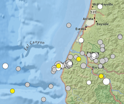
For almost a month following the Dec. 20 earthquake that devastated parts of the county, over 80 aftershocks of magnitude 2.5 or greater have gently shaken Humboldt- most too small to be felt. Large earthquakes in fault-prone areas like Humboldt may change the stresses on adjacent faults.
“The kind of earthquake that fault produced, with that kind of slip, can produce a pattern of stresses which, in some instances can promote a nearby fault to be closer to failing,” said Dr Mark Hemphill-Haley, a geology professor at Cal Poly Humboldt.
Some shifts release stress to delay an earthquake, while some increase stress. This can trigger new movement as the fault system searches for a new equilibrium. The pattern of aftershocks can provide important clues into the state of the fault system.
“From just the 2.5s, you can kind of get an idea of how they ruptured along the subduction zone,” said John Bellini, geophysicist at the USGS National Earthquake Information Center.
However, accurate triangulation of the Ferndale quake’s epicenter and those of its aftershocks is complicated by the fact that the fault system lies largely offshore.
“Because all of the stations are onshore and the main shock was just offshore, you don’t get as meaningful distribution,” said Bellini.
Judging from the distribution of the aftershocks, one might think that they followed East-Northeast running faults. However, data is often deceptive.
“If you look at the trends of the faults, they are Southeast to Northwest,” said Bellini. “This misleading artifact of the map is due to imprecision in triangulation- in order to locate the epicenter of an earthquake, it must be recorded from three different seismic stations.”
The more surrounded the earthquake is by seismic stations, the greater one’s ability to measure it precisely. Because the closest ‘western’ seismic stations are in Hawaii, precise observation of seismic activity off the Humboldt coast is difficult.
Image courtesy of USGS | Fault distribution in the North American Plate.
“Most of the stations for most of those quakes are going to be to the east, with nothing to the west for most of them… when that happens, the error ellipsoid for them is going to be stretched in an east-west direction,” said Bellini.
Humboldt County sits at the very south tip of the Cascadia subduction zone, where the Gorda/Juan de Fuca, Pacific and North American tectonic plates come together in a geologically complex region called a triple junction.
The difficulty of studying the complex tectonic interactions at this triple junction is compounded by the fact that it lies half offshore, however new developments in geology have lifted the veil on offshore tectonics.
Last summer, researchers from Cal Poly Humboldt’s geology department along with researchers from the US Geological Survey, UC Berkeley, and University of Washington installed over 40 seismometers along an optical fiber cable that runs from Aracata to Eureka. Instruments connected to the optical fiber along with the seismometers provided high resolution about the local seismicity. The instruments were removed after their testing period was complete, but they were reinstalled immediately in the aftermath of the Dec 20, 2022 Ferndale earthquake.
The use of fiber optic cables for monitoring earthquakes is very recent, but a huge development for geology in areas like Humboldt.
“We’ve already recorded more than a hundred aftershocks associated with that recent quake,” said Dr. Hemphill-Haley.
A comet is a ball of ice which burns up when it passes the sun. That burn-off is what is seen by the human eye. On February 1, the green comet known as C/2022 E3 (ZTF) was at its closest and able to be seen by the naked eye, though it was 26 million miles from Earth.
Though it was visible in the Northern Hemisphere, the conditions in Humboldt were not optimal for viewing. Many may have had a hard time seeing this comet, referred to as C/2022, due to fog and pollution in the sky. For those who missed it on Feb. 1, it was still visible by telescope or binoculars Feb. 2.
Comets have an elliptical orbit. They spin close to the sun and then away from it, interacting with the gravity of other objects along the way. When they pass by the sun, they sometimes become visible from Earth. What we see is the comet releasing gasses.
Comets are from the outer solar system and they spend most of their lives very far from the sun. Tyler Mitchell, a physics professor at Cal Poly Humboldt, refers to them as, “little time capsules of frozen ices and a variety of different types of dust, like carbon and silicates.”
C/2022 is a green comet. “The color comes from two carbon atoms stuck together,” said Mitchell. “The tails of most comets are yellow.”
To Tanner B. Hooven, a student and member of the Cal Poly Humboldt Astronomy Club, C/2022 is a reminder of Earth’s past. We are the first people since the recording of time to see this comet.
“This comet is special because of its orbital period, or the time it takes to make one full journey around the sun, is approximately 50,000 years according to Nasa’s Jet Propulsion Laboratory,” Hooven said. “The last time this comet approached its perigee was at a time in which Neanderthals were still roaming the earth.”
Comets are sometimes called “dirty ice balls”, though they should be referred to as an icy dirt ball, given their respective ratios. Comets can become asteroids, which are referred to as “dormant comets.”
When identifying comets, or asteroids, astronomers look for what is essentially a “photobomb” and streak that was not previously there, or a bright shining star that was not before visible, according to Mitchell.
This comet is currently on its way out of the inner solar system. It will take months for it to fade from our view.
“It is likely this comet will continue to orbit the sun for millions of years until the off-gassing process subsides due to a lack of ice left in the comet,” Hooven said.
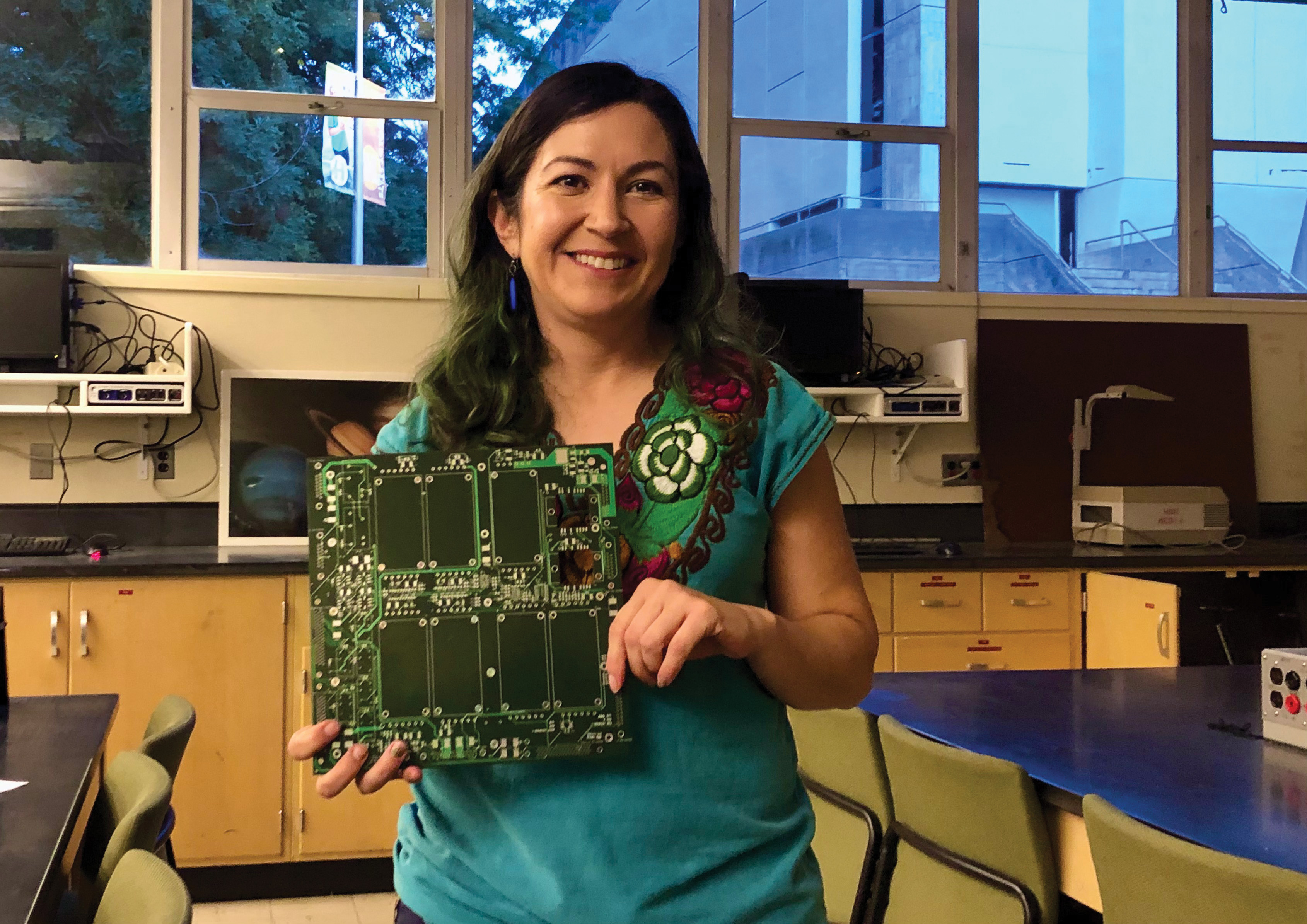
Jessica Bowles-Martinez, an ex-NASA engineer and “systems engineer, aka science wrangler,” spoke to Cal Poly Humboldt students on Monday. About 20 attendees gathered in Science A 475, sipping coffee and hot chocolate as late-afternoon gray rainy light filtered through the windows.
The seminar, “Wrangling Scientists and Engineers to Make Something Awesome – Systems Engineering” was put on by the CPH Physics Department. It focused on Bowles-Martinez’s role in various NASA projects, defining what a systems engineer’s role is in these exacting and large-scale endeavors.
After graduating high school in Fresno, California, Bowles-Martinez attended MIT where she majored in electrical engineering, computer science, and media studies.
In her 13 years working at NASA’s Pasadena-based Jet Propulsion Laboratory (JPL) Bowles-Martinez was on the team for many high-profile projects. She worked on New Horizons, which was the first probe sent to explore Pluto up close, as well as the OPALS (Optical Payload for Lasercomm Science) laser data transfer project on the ISS. Her other projects include the Perseverance Mars rover and the Europa Clipper, which will fly by Jupiter’s fourth-largest satellite and assess it for markers of life.
As a systems engineer, Bowles-Martinez’s role on projects is to facilitate communication and collaboration between the science team, engineering team, and the team that actually builds the finished design.
“It’s not just checking the boxes, it’s about ‘does it all work together?’” she said.
There were many problems which the OPALS team had to contend with to ensure a successful outcome, according to Bowles-Martinez. The entire project, which was attached to the outside of the ISS, was a test of an experimental method of data transfer, which would add the capability to send high-res video from the station. The laser used on the module was potentially dangerous to the astronauts on board the ISS, so there needed to be extensive safety measures around its deployment.
“Because this laser is class 4, if an astronaut looked at it they would go blind. So we had to figure out how you make a system that will be safe enough to have it be on the space station and shoot this laser down to Earth; all the safety controls are there,” Bowles-Martinez said. “My job is to be in the middle of everyone on that type of stuff.”
As a systems engineer on the Perseverance rover, Bowles-Martinez worked on the systems which brought the rover safely down from orbit onto the planet’s surface, as well as the systems which launched the Ingenuity Mars helicopter from the main body of the rover.
To physics and engineering students hoping for a career in NASA, Bowles-Martinez stressed the importance of internships and especially programming experience.
Systems engineering is a little-known field, but absolutely essential to every NASA endeavor.
“It’s a really intricate science dance, almost,” Bowles-Martinez said.
The edges of Humboldt Bay are on the verge of being overrun by the sea. It laps at the boundaries of Highway 101, surrounds the Arcata Marsh, and sneaks around the corners of low-lying industrial areas in Eureka.
SINKING SHORELINE
Humboldt’s location at the end of the Cascadia Subduction Zone makes the area more vulnerable to sea level rise than any other location on the California coast. Due to its position in a very active tectonic area and the specific activity of the surrounding plates, the Humboldt County region is steadily sinking, or subsiding.
The Humboldt Bay Vertical Reference System Working Group is a research group focused on identifying geology’s role in Humboldt Bay sea level rise. In a 2017 report, they found that land subsidence contributes to sea level rise 2 to 3 times more in Humboldt County than anywhere else in California. Of the 18 inch rise in sea levels that has occurred locally in the past century, an estimated 50% is due to tectonic subsidence.
“The ocean isn’t rising any faster off of our coast than it is down in San Francisco, but we have subsidence that the rest of California doesn’t have,” said environmental planning consultant Aldaron Laird.
Laird has been an essential part of local sea level rise risk assessment and adaptation planning over the last decade, consulting with Humboldt County and various local districts.
ADAPTATION PLANNING
Humboldt County has commissioned many reports which assess the risk that sea level rise poses to infrastructure and communities. These contextualize what different levels of sea level rise will mean, and suggest possible adaptation measures. However, the reports do not implement the adaptation measures.
The most recent grant-funded project to tackle this issue concluded in 2019, yet none of the recommendations from that, or any other report, have been implemented.
An area that the reports do not touch on is the potential for industrial contamination in the bay as sea level rise reaches new areas.
In her career as an environmental advocate, Jennifer Kalt has observed the local government’s lackluster reaction to the threat of sea level rise for years.
“What I have seen as a repeating theme is a lot of local jurisdictions getting grant money to develop plans and then there isn’t a plan,” said Kalt. “It’s a little depressing to see so much planning lead to nothing.”
Michael Richardson is a supervising planner of long range planning in the Humboldt County Planning and Building Department, which is responsible for sea level rise adaptation planning. He said that the county would like to decide on terms of collaboration with other local jurisdictions before they plan to implement any sea level rise adaptation measures. Simply put, they don’t have immediate plans to do anything specific.
“There would be a different process to go forward with getting the cities and the county on the same page and whatever agreements need to be made,” said Richardson. “What that plan looks like is what we’re still figuring out.”
Kalt doesn’t think that the pace at which the government is moving on this issue will make a difference in time. In addition to protecting residential areas, she said that their focus should be on relocating key infrastructure.
“I’m concerned that a lot of the agencies that need to address these problems, there’s not a lot of political will to do what needs to be done,” said Kalt.
There are many organizations with an interest in adapting Humboldt Bay to meet the challenge of sea level rise. The Coastal Commission, CalTrans, Humboldt County, local city governments, and even the state government of California all hold potential responsibility for the threatened areas. Kalt doesn’t see any of them doing anything to prepare.
“It’s a Humboldt County pastime to finger-point,” said Kalt.
A recent report released as part of the county’s Humboldt Bay Sea Level Rise Regional Planning Feasibility Study extensively details what theoretical responsibility a variety of local, state, and federal jurisdictions would have to combat sea level rise, but does not lay out a plan for collaboration. A further report is expected to be published before the end of 2022, recommending a strategy for collaboration.
If nothing is done to adapt to the changing coastline, life around Humboldt Bay will look very different in 50 years. Infrastructure-rich areas will be reclaimed by the tide, and local government and utilities companies alike will have to find ways to work with the new bay. It is also worth considering that any adaptation measures will likely take significant time and resources to complete given their cost and scale.
KING SALMON
One of the first areas in Humboldt to be substantially impacted by sea level rise is the unincorporated community of King Salmon. This oceanside community is located across from the mouth of Humboldt Bay just south of Eureka, exposing it to the full brunt of tidal forces. Sunbleached houses, mobile homes, and a few small businesses line canals. It is located only 3 feet above sea level.
In early January 2022, there was a flooding event in King Salmon caused by king tides coinciding with the rain and high winds from a storm. Photos depict residents kayaking down the street or wading shin-deep in water. Little structural damage was done, but it was obvious that King Salmon is at extreme risk as sea levels continue to rise.
Parts of the community are only accessible via a single bridge on King Salmon avenue. Any tide which overtook this could leave residents with no method of escape. In a 2022 Humboldt County Civil Grand Jury report, this is predicted to occur within 3 feet of sea level rise, possible as soon as 2070.
INFRASTRUCTURE
Other significant infrastructure endangered by the amount of sea level rise listed in the report include PG&E’s Humboldt Bay Power Plant (HBPP) complex, Highway 101 as it traverses the bay, and water and electrical transmission lines. Several sites contaminated with industrial waste will also be reached by tides at this level..
According to a report authored by Laird, 1.6 feet of sea level rise, possible by 2040, will put King Salmon underwater during king tides. Sea level rise of 3.3 feet, predicted to occur by 2065, will cause the tides to overtake most of the area daily.
According to Laird, the most pressing threat to King Salmon is whether utilities will continue to be available to its residents. “It only takes one utility to stop providing service and you wouldn’t be able to live there anymore,” he said.
PG&E’s Humboldt Bay Generating Station, located in King Salmon, supplies power to around 67,000 people. It is predicted to be threatened by king tides by 2065. The plant will have to be relocated or otherwise protected from the tides in the near future if it is to continue supplying power to Humboldt County.
The Humboldt Bay Independent Spent Fuel Storage Installation, a nuclear waste storage facility, is located on the HBPP campus. It houses the spent fuel from the Bay Generating Station’s nuclear predecessor. There are currently no plans to relocate the spent nuclear fuel stored there.
HERE AND NOW
Participants in the Humboldt Baykeeper’s King Tides Photo Initiative have found evidence of high water levels affecting Humboldt County here and now. Founded in 2004, Humboldt Baykeeper is an advocacy organization which focuses on preserving coastal resources around the bay. They monitor levels of contaminants present in the bay, assess new industrial developments, and catalog the effects of sea level rise.
The King Tides Photo Initiative encourages members of the community to document areas inundated by high tide levels. In many of these photos, residential areas around the bay are actively being overrun by the sea. Some of the images aggregated on Baykeeper’s Facebook page show the Highway 255 bridge over Mad River Slough nearly overtopped, Jackson Ranch Road in the Arcata Bottoms covered with water, and waves crashing over a parking lot at the Arcata Marsh.
The Highway 101 corridor is one of the areas where tidal inundation is starkly visible. Despite the bay’s encroachment, there are ongoing plans to extend the Humboldt Bay Trail along that same strip to reach Eureka.
DIKED SHORELINE
Humboldt County and the Eel River Delta are uniquely vulnerable to sea level rise. The historical legacy of diking the shoreline in order to create more usable land has led to a large concentration of critical infrastructure in former salt marsh lands, according to Laird.
A large portion of Humboldt County’s critical infrastructure is concentrated in former salt marsh lands. This land is made accessible and flood-proofed by a system of dikes which will not stand up to sea level rise.
“Highway 101, Highway 255, municipal water lines, wastewater treatment lines, natural gas lines, optical fiber lines; all of this infrastructure is built on that former tideland which is prevented from saltwater inundation only by the diked shoreline,” said Laird.
The location of this infrastructure in former tidelands means that a breach in any one dike could result in the entire area being flooded. “We don’t have to wait for sea level rise to see the impacts of reclaiming the diked former tidelands,” said Laird.
Even if every dike around the bay holds against today’s water levels, they will be overtopped by 2 to 3 feet of sea level rise by 2040 at the earliest, and 2060 at the latest. Additionally, there is no bay-wide district in charge of maintaining the dikes. Instead, over 100 shoreline parcels are individually managed by local jurisdictions.
It costs millions of dollars to rebuild even one mile of diked shoreline, and the raw materials to rebuild are not readily available in the quantities that would be needed.
“If we can’t address these and do anything about it, I think the first thing that’s going to happen is the dikes…they’re going to fail,” said Laird. “They’re going to breach and the bay is going to reclaim the 7 to 9 thousand acres of tide lands that used to be part of it. It’s the areas that we gobbled up from the bay over a century ago, those are the ones that are most vulnerable.”
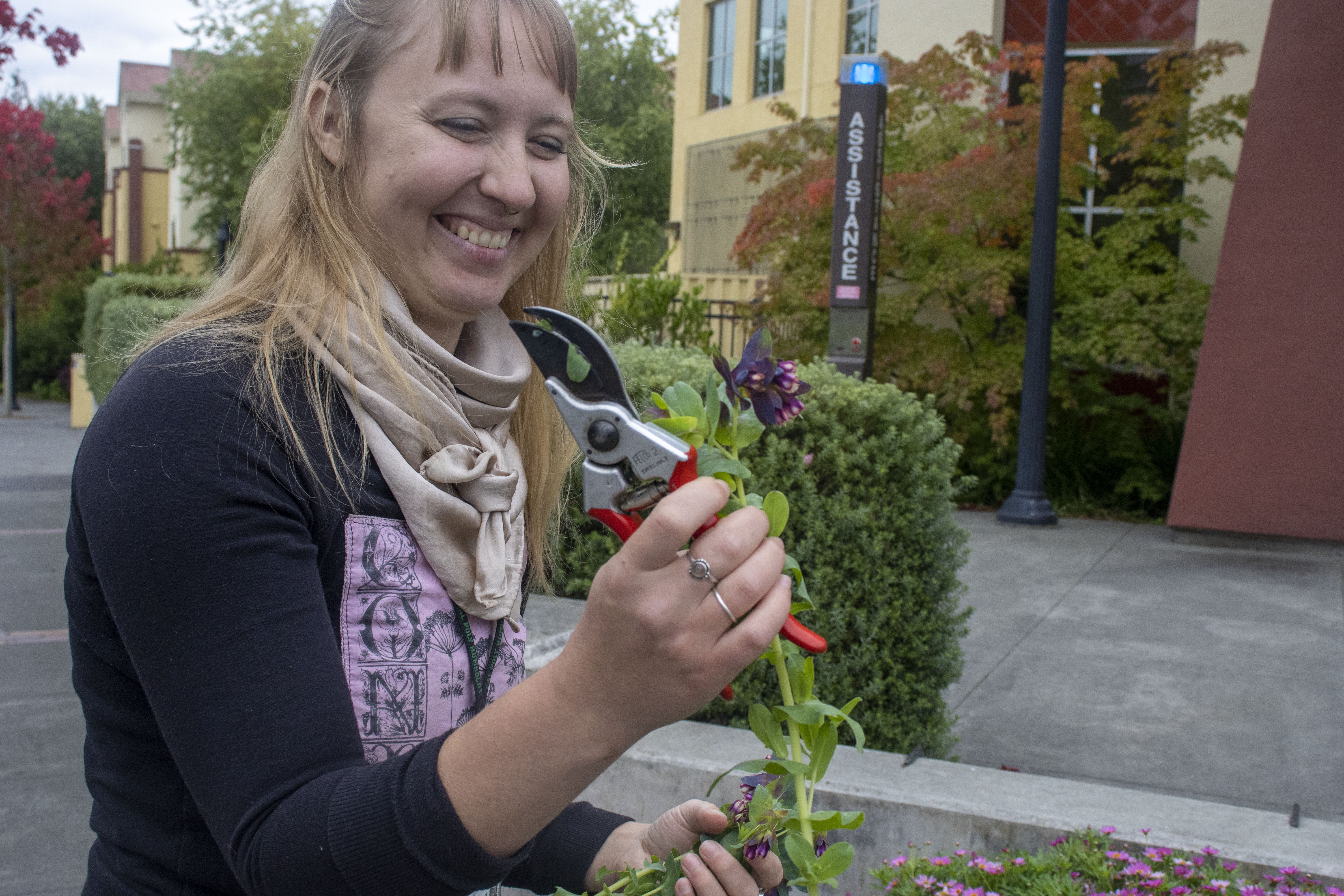
Sunday mornings, you’ll find most college students tucked away in their beds catching up on sleep, or maybe packing away their notes for a long day at the library. Nearly every Sunday morning you can find Heather Davis perusing campus bushes and trees; wielding red Felco pruners, or “snips” as she likes to call them, in one hand and a clump of wrinkly brown paper grocery bags in the other.
Davis isn’t going on a big grocery trip or planning to do any landscaping, rather she is harvesting plant specimens around campus for botany majors and BOT 350 (Plant Taxonomy) students. Davis is the plant collector for Dr. Oscar Vargas’s Plant Taxonomy class this year.
“The labs are Monday, Tuesday, Wednesday, and Thursday,” said Davis. “So I usually collect Sunday for Monday and Tuesday labs and then I collect Tuesday for Wednesday and Thursday labs.
With over 120 students enrolled in plant taxonomy this semester, Davis has her hands full nearly every week. On top of being a botany student herself, the Tulsa, Oklahoma native is balancing her two children with the 16 units she’s taking this semester. She made her way to Humboldt county nearly a decade ago in the pursuit of organic farming and decided to start studying for her degree in botany in 2019.
“I was really interested in organic farming and more natural practices, everything in the Midwest is super mono-cropped and sprayed and really gnarly,” said Davis. “A friend was here in Willow Creek working for a farmer and they were like you should come check it out and like, be a part of the community here so we came out here and worked for that farmer for two seasons.”
Davis’s passion for plant collecting shows. She comes to Science D nearly every Sunday around 9:30 a.m, bringing along her infectious smile and a bright blue stainless steel mug decorated with an artistic owl sticker. There are dried leaves carefully placed in the back of her iPhone case, and she sports a black long sleeve shirt printed with various weeds and flowers as her uniform of choice.
Davis usually begins her collection process by making her way into the Plant Taxonomy storage room located in room 153 in Science D, to prepare large clear bins with moist paper towels for collection storage. The room has rows of labeled jars filled with dried leaves, stems, and clippings. Some are simple masking tape categories, but there are also some printed skulls and crossbones, warning handlers of the plant’s poisonous properties.
Davis was inspired by her previous botany professors to pursue this job, Dr. Oscar Vargas and Stefani Brandt. She was especially interested after taking the plant taxonomy lab for herself.
“Both of them are amazing instructors, they were super inspiring, Stephanie especially,” said Davis. “I was like ‘aw I wanna be a part of this but I didn’t realize there was a plant collector until they offered the job up to the students in the class”
Davis isn’t afraid to dive headfirst into her collecting job, she haphazardly snips away different flowers and shrubs surrounding the Natural Resources building and College Creek Marketplace. She climbs trees to collect specific branches and tastes the tart huckleberries around campus before collecting them for storage. Most of her collecting is done on campus, but she sometimes can make her way up to Trinidad for specific specimens.
“I collect all over the place,” said Davis. “Campus mostly cause there’s a lot of really awesome plants already growing here but there’s a few like invasive or cultivars that they need for the lab, so I’ll end up going to the marsh or sometimes random people’s yards around town, a little reconnaissance.”
Davis appreciates this position for allowing her to explore the nooks and crannies on campus and doesn’t seem to mind the business it brings into her already hectic schedule of being a mom and student in STEM.
“I think it’s really cool to walk around campus and see how many plants are here. Before I started the position I was like ‘it’s going to be so hard to find all these plants, like campus is all Rhododendrons,’ said Davis. “Then I started walking around and these plants are everywhere, it’s so cool to be like ‘Oh Hey I didn’t see you before.’”
Davis also mentioned sharing her love of plants with her children as well.
“My kids get involved, if you come in here you’ll definitely see them walking around with giant plants, said Davis. “They really love it, they’re inspired by science so it’s really fun to bring them in, they can look at the microscopes and see all the jarred plant specimens in the prep room and stuff.”
Davis is the embodiment of finding joy in your career. Her bubbly personality and vast knowledge of native plants, grasses, and even weeds is hard to ignore in any conversation with her. She’s become an expert at balancing work and play in her jam packed schedule.
“It’s definitely a ton of work being a botany major or a stem major in general but it’s so worth it,” said Davis. “I think it’s really cool to see that there’s plant collecting happening, and that there are these really fun jobs that you can do on campus and I’m inspired and love it.”
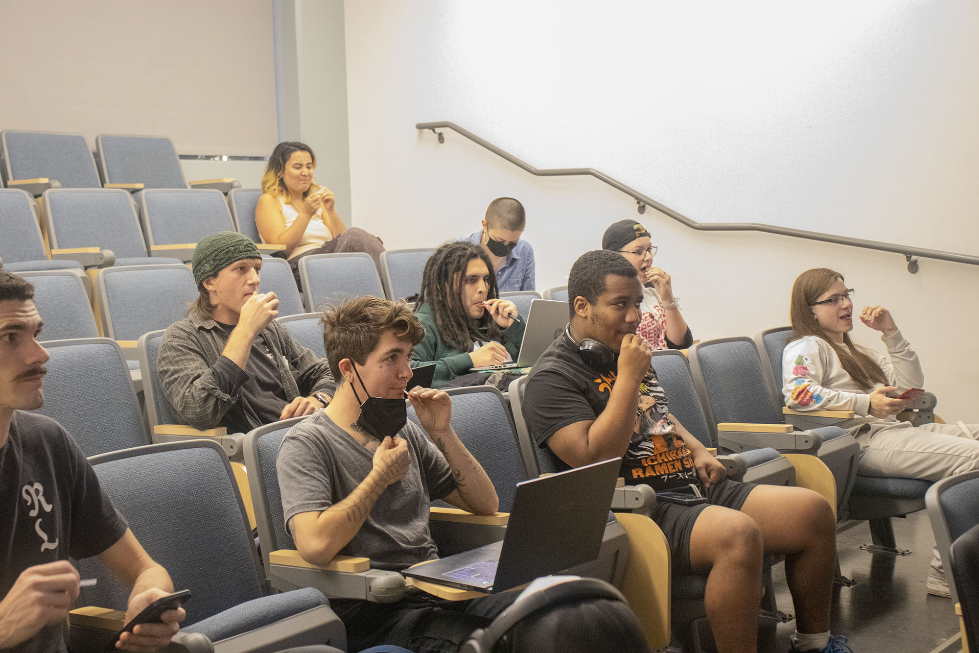
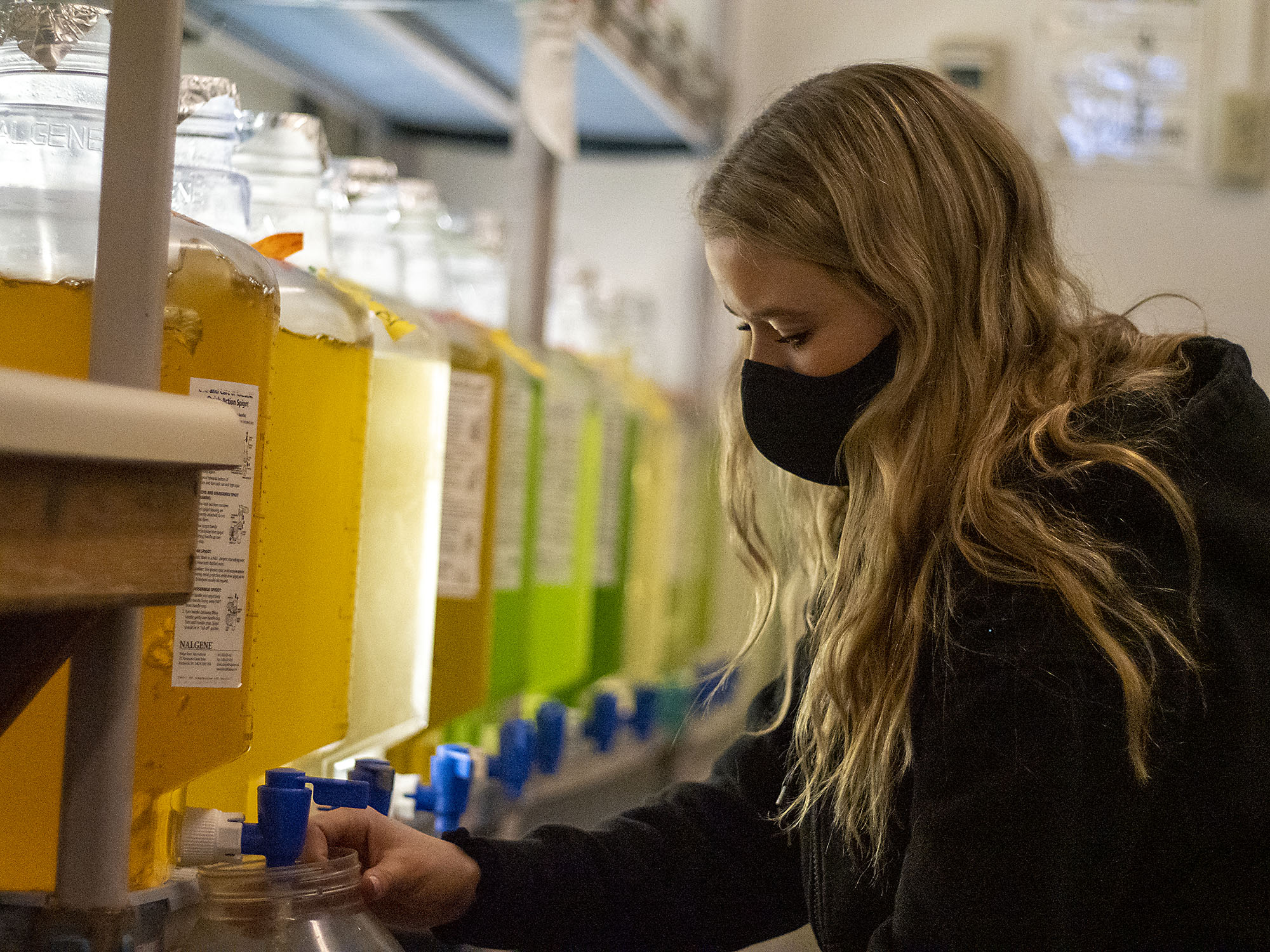
On Sep. 20 in room 564 of the science A building, approximately 20 people ingested a toxic chemical known as propylthiouracil. It was not a mass suicide attempt. It was not a Jonestown re-enactment, nor were they getting high. It was a meeting of the Humboldt chemistry club.
Propylthiouracil is a chemical used to test if an individual is especially sensitive to taste, someone known as a “supertaster.” If the paper containing the substance was especially bitter, then chances are good that person is a supertaster. The members of the Free Radicals, the chemistry club on campus, were testing if they were supertasters.
“I just put poison on my tongue, so I guess I’m ok with anything,” laughed member Angela Takahara.
If the energy of the Free Radicals could be put into one quote, that would probably be it.
“People. That’s the best part,” club president Jack McLaughlin said. “It’s probably the best place for chemistry majors and a lot of other majors to socialize. It’s just a great community to have and to talk to, because not a lot of other people really understand chemistry…it’s nice to have people who understand you, where you don’t have to explain every other concept.”
McLaughlin joined the club his freshman year, and hasn’t regretted it once. He said it’s an excellent way to get connected with important resources and more experienced students, as well as guest speakers who are in the industry or are teaching currently.
“It really helps guide newer students and even sophomores, juniors, and such towards figuring out what to do with their chemistry degree,” McLaughlin said, “And also how to make the most out of college.”
The Free Radicals aren’t only open to those working on chemistry degrees, however. Shay Konradsdottir, the club’s Social Director and Events Coordinator, is a molecular biology and computer science double major, with only a minor in chemistry. Her favorite part of being in the club is putting events on, such as a tie-dye event the club held last semester to showcase the science of colors.
“As social coordinator here, I really enjoy planning the events and making fun things,” Konradsdottir said. “Making this stuff, and sharing this interest in the sciences and interest in chemistry in a way that’s not just ‘here’s what the reactions are called.’”
And it is that interest in chemistry that binds all of the members together. McLaughlin said the nature of chemistry being everywhere was the appeal, and how it oftentimes was the key to understanding so much of life.
“[Chemistry] is like the building blocks of the universe,” McLaughlin said. “…I feel like I can pursue all of my passions for environmentalism and such through chemistry.”
Senior Sam Emerson, attending his first meeting at the Chemistry Club, holds a similar viewpoint.
“I like figuring out what makes the universe run the way it does,” Emerson said. “It feels like getting to know the game engine behind everything…I’ve always thought life was really fascinating and that although the universe prefers disorder, there are certain, random spins of chemicals that happen to make order out of nothing.”
Konradsdottir, who Emerson credits with convincing him to join the Free Radicals, has a much more personal background with science and how it interacts with their lives. She was diagnosed with Type 1 diabetes when she was young, and was a subject in medical studies. It was a defining moment in her life, she said, and it inspired her to become a doctor and help people. Eventually, she became interested in coding, and that led her to where she is today; gunning for an MD-PhD and potentially opening her own free clinic or making more effective medical diagnostic tools.
“I felt really awful about when I’ve heard stories from my friends or even some family members that were prevented from doing the things they loved doing because they got an injury or they got sick,” Konradsdottir said. “I myself, being a diabetic, there are lots of things I missed out on because I’m a diabetic, so being able to catch those things and prevent them from happening–that’s interesting to me.”
Being the club events coordinator, Konradsdottir hopes to share that fascination with the rest of campus. Last semester, she went on a field trip where she got to make a pleasant-smelling chemical, but wasn’t allowed to take any home. If the club had unlimited money, she would hold an event where anyone could show up, get a free lab coat and goggles, and concoct something similar to what she got to make–with the difference being they would get to keep it.
“It’s fun! We just do fun stuff here,” McLaughlin said. “It’s not like actual work…you don’t have to understand anything about chemistry, so long as you show up with a good attitude.”
Mycology is a very young science, a baby in fact. Up until 1969, Fungi did not even have their own kingdom, as they do now, but were technically considered to be plants. Mushrooms are not plants, contrary to what many may believe.
Some of the most prominent and common mushrooms in Humboldt are actually the edible ones such as the King Bolete and the Pacific Golden Chanterelle. According to Cal Poly Humboldt Mycology Club President Jack Mccann both of these mushrooms are very delicious.
Mccann said what brought him to the Mycology club was cooking.
“As a mushroom person I really love to cook,” said Mccann. “I think I like to cook first, that’s part of what got me into mushrooms, it’s just cause it opens a whole new world of food,” said Mccann.
The club holds weekly mushroom hikes on Fridays, which are open to everybody regardless of club membership. This is a chance for the hikers to go out and experience the forest through a mycologist’s perspective. Every alternating Friday, they host workshops and guest lecturers. These meetings are more targeted towards people who already know about fungi.
The Mycology club is having a two day DNA barcoding workshop on September 30th-October 1, 2022. The club members will learn about the process used to genetically test the species of a mushroom. This process can often lead to the discovery of new species. During the workshop, club members will see if there is a difference between different mushrooms on a genetic level.
“We’re gonna borrow a lab and, basically in a pretty sterile environment you separate the mushroom using some primers, seek out the genes you’re looking for and then amplify those genes so you could actually read them,” said Mccan.
Essentially, what Mccan said is that the club will be collecting mushrooms and then using their DNA to see if there are any genetic differences between species of mushrooms.
“The machine, known as a thermal cycler, gives you a visual representation of what it looks like, you compare it to what it’s supposed to look like, what you’re expecting.” All of the prep work will be done at the two day workshop. This includes the collection, the DNA sequencing and the comparison of the DNA.
Then, their guest speaker Damon Tighe will get back to them with the results. Tighe is a mycologist working out of Oakland and is working with the Company Bio-Rad. He is driving into Humboldt with all the equipment.
The logging industry has a negative impact on mushroom culture. Unlike foragers, who simply take the ‘extension’ so to speak, of the fungi, what is known as the fruiting bodies, loggers do damage with their machines that dig into the ground.
Logging practices harm the mycelium, the other part of the fungus’ body. Mycelium is a root-like network that grows under the soil, it is what produces the fruiting bodies we know as mushrooms. According to Tighe, mycelium is just the vegetative state of a fungus.
Treasurer Sam Parker said he was drawn to the foraging aspect of Mycology.
“I first learned to do that when I was around eight with morels, and I just love being out in the woods,” said Parker “Mushrooms are a very diverse lifeform and I feel like they just kinda tie everything together, and I just think they are just interesting to learn about,” said Parker.
For Amber Chung, sustainability is everything. As an environmental science management major and the student leader of Cal Poly Humboldt’s Green Campus Team, Chung says she has been in love with the environment since she was a kid.
She said watching and reading “The Lorax” by Dr. Seuss opened her eyes as a child to the need for sustainability.
“I really saw for the first time like wow, like what we do literally does matter. It can change the whole environment like it did there,” Chung said. “Now that I’ve gotten older, I’ve realized that sustainability is such a wide concept, it has to be in everything for everything else to work. If you don’t center sustainability, you’re not really going to get anywhere with anything else, because it’s not going to last long term.”
As a branch of the Office of Sustainability, the Green Campus Team is an organization that consists of five student employees and one staff advisor. Their goal is to encourage everyone on campus to center sustainability in everything they do.
The team provides educational materials and advice for groups on campus on how to be as sustainable as possible while still having fun. In the coming months the team will hold a “Trashion” show where students can create outfits out of trash or other items that were about to be thrown away and a “Weigh the Waste” event to educate the campus community about the effects of food waste.
This semester the Green Campus Team will also relaunch the Green Workplace Assessment Program, including a new sub-program called the Peer To Peer Education Program. Advocates will talk to campus departments and educate them on sustainable practices so they can properly educate their peers.
They will also launch a student version of this program called Equal Reps, recruiting students that live on campus to educate others about living green.
“It would be great if students, before doing any sort of action, just considered the question and the idea of ‘how can what I’m doing be more sustainable?’” Chung said. “How can I do this in a different way?”
Chung said this could mean many different things and will look different for everyone.
“It could mean completely changing what you’re doing. It could be evaluating if you have the capacity to do more sustainable actions because sometimes there just simply isn’t a possibility with other things you have going on,” Chung said.
The Waste Reduction and Resource Awareness Program has brought back the paper towel composting project this semester. WRRAP also gives out composting buckets for on-campus residents, as well as finished compost to anyone who wants it.
“Students should keep an eye out for signs in the restrooms marking which bin is for paper towels and which is for other waste,” WRRAP said in an email to the Lumberjack. “This is a great help when we go to do our final sorting before placing the paper towels in the on-campus industrial composter.”
Chung explained that when planning events the campus should account for sustainability rather than making adjustments later. Chung suggested that the administration should foster an open dialogue with the Office of Sustainability to ensure that they are making the best decisions for the school long-term.
“I think continuing to make sure that [the administration is] keeping sustainability at a forefront rather than an afterthought would be really important for the school,” Chung said. “Especially as we’re making so many big decisions with the new Cal Poly change.”
The Green Campus Team has compiled the Zero Waste Event Certification Checklist of different things to keep in mind when planning an event on campus. The checklist includes helpful sustainability tips, like serving food buffet style in reusable containers and ensuring promotional or advertising materials and decorations are reusable, recyclable or compostable.
The Green Campus Team is currently looking for another student employee as well as experiential interns and volunteers. To learn more follow the Green Campus Team on Instagram @greencampus_humboldt.
After the consuming heat and flame of a wildfire, flooding seems an unlikely problem to have to worry about. But catastrophic floods after a section of land is burned often threaten both human settlements and ecosystems.
Post-wildfire flooding can be caused by several processes. According to Cal Poly Humboldt professor of forestry, fire and rangeland management Dr. Jeff Kane, the forest floor normally acts as a sponge, soaking up and slowly releasing rainfall. When a wildfire burns that layer, there’s nothing left behind to stop rainfall from rushing directly downstream.
Wildfire also can release and vaporize waxy compounds from conifer needles, which then accumulate on the burned ground and form an even more water-resistant layer.
“Instead of percolating, [water] may flow overland,” Kane said. “If you don’t have the vegetation to absorb the precipitation, then it’s going to be more impactful.”
Hydrology and watershed management professor Dr. Andrew Stubblefield says that the impacts of this flooding extend to the whole ecosystem. When the forest floor loses its ability to absorb water, the topsoil can become saturated and eventually sloughs downstream, taking with it the nutrients it stores.
“Now you have a forest that’s less able to hold water to grow trees and provide nutrients to grow trees,” said Stubblefield. “It’s impoverished, or it’s depleted; and it can take a while to hundreds of years even to rebuild the nutrients.”
This can impact what plants regrow while the land recovers from the fire and flood. Weedy, often-invasive plants may have an easier time reestablishing themselves in this less-nurturing environment than native species, according to Kane.
Soil and nutrients washed into rivers and streams also negatively affect their ecosystems. Sediment and debris carried by flooding associated with the McKinney fire caused fish kill in the Klamath River earlier this August, as clays in the soil interrupted oxygen flow and nutrients nourished a deadly algal bloom.
Post-wildfire flooding can also be dangerous to human settlements and to the ecosystem around it because it picks up debris and soil and carries it downstream. Debris flows caused by heavy rain after the Thomas fire in Montecito, California killed 23, injured at least 167, and damaged 408 homes, according to a 2019 research article by J.W. Kean et al.
It’s the charge of the National Forest Service’s BAER (Burned Area Emergency Response) teams to analyze the risks for flooding after each fire and implement measures to mitigate damage and environmental impacts. According to the McKinney Post-Fire BAER incident overview, these multidisciplinary teams of scientists decide what, if anything, needs to be done to protect natural resources or human settlements in the area.
Examples of possible interventions include seeding the hillside from the air, setting up log breaks along hills or in creek beds, or stabilizing at-risk areas with hydro-mulch (a material similar to paper mâché which also contains seeds,) said Stubblefield. Sometimes the best treatment is to warn people away from at-risk areas with weather alerts when a big storm is coming in.
But with modern fires often burning millions of acres at once, what scientists can do to mitigate flooding becomes a problem of scale.
“The August Complex [fire] last summer was a million acres, what would it cost to try and stabilize that landscape, you know, it’s too big,” said Stubblefield. “It would be the gross domestic product of a small country.”
Flooding is not an inevitable follow-up to wildfire. It takes both intense fire and intense rain to create the right conditions. If ground cover vegetation like grasses have time to return before the next intense rain, it stabilizes the soil and can even begin to break down the waxy hydrophobic layer.
However, due to the effects of anthropogenic climate change and poor forest management, the perfect storm happens more often.
When this land was stewarded by Native Americans, regular fires were part of that management. In the post-colonial absence of that management, white settlers saw wildfires as something that needed to be suppressed immediately, rather than allowed to run their course as a physiological process of the forest. When the dense, thick, choked forests that this policy produces catch fire, they burn hotter, longer, and over a wider area. The environmental legacy of clear-cut logging and fire-prevention has left the forests in a vulnerable and volatile state.
“We are moving into an era of active fire management,” said Stubblefield.
This means more prescribed burns, and an attitude towards fire that acknowledges its essential role in forest health. Post-fire flooding, too, is a physiological component of the ecosystem. According to Stubblefield, if sediments weren’t carried into the river, salmon might not have gravel to spawn on at all.
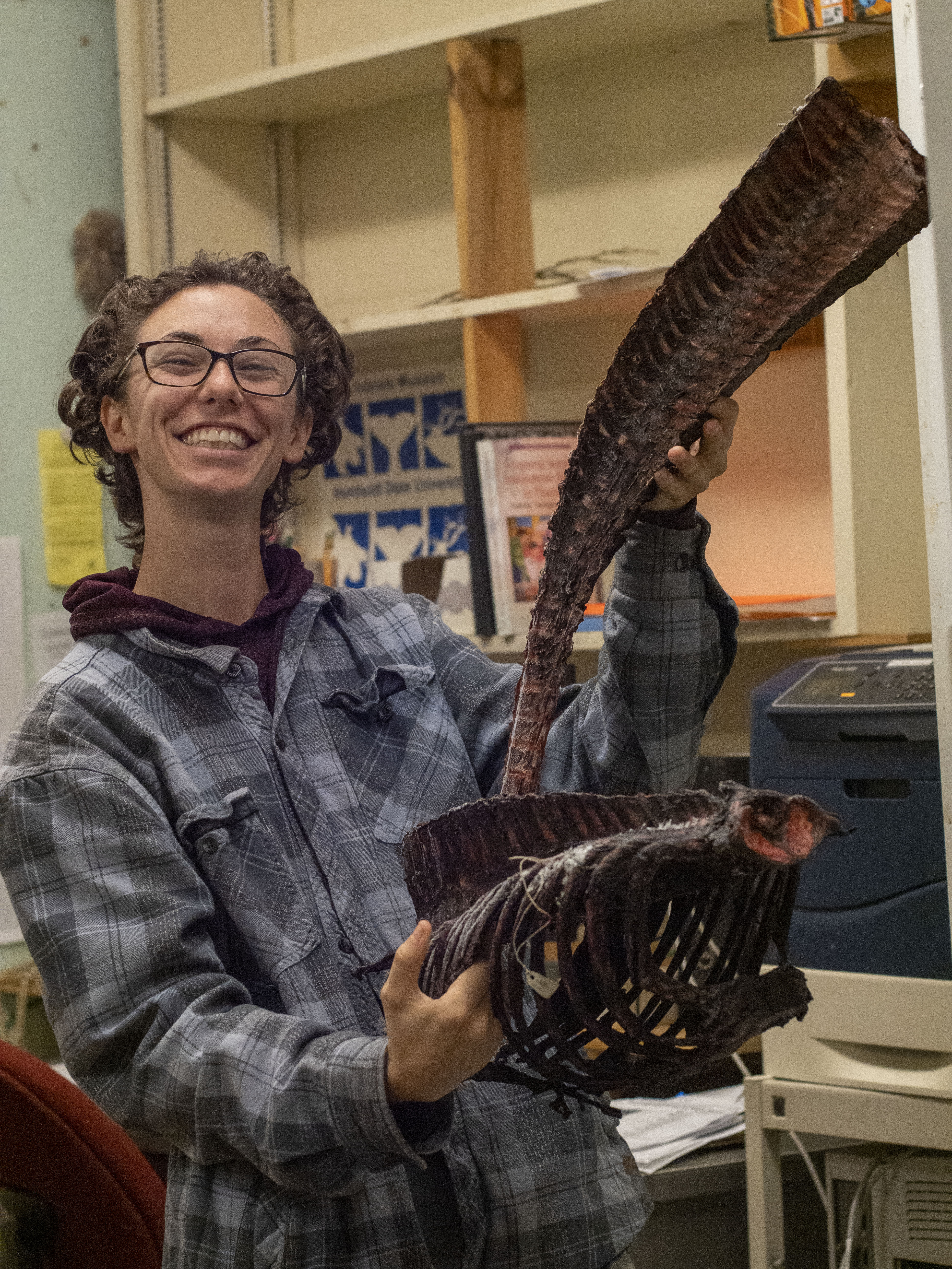
Cal Poly Humboldt’s campus has a vertebrate museum, dedicated to skulls, skeletons, skins, and tissue from various mammals and vertebrates, such as rats, mice, and sea mammals native to Humboldt county. This student-run museum has about 15,000 specimens, 9,000 of which are available for viewing.
The museum is now allowing all students a peek into their collections, which include rodents, otters, seals, and taxidermied elk. Students are also able to view the anatomical study processes such as dissection and labeling.
Previously, the collection was only accessible to students within the wildlife major. The students would look through the collection and study the specimens, testing their ability to identify them. Now, for the first time since the museum was established in 1969, the museum is open to all students during their open hours on Monday from 11am to 4pm, and Tuesdays through Fridays 12pm to 5pm.
Shea Daly, a senior who works in the lab and does most of the preparations, extended an open invitation to all students.
“On the last Friday of the month, we are going to have open labs and live dissections, so come in and ask questions,” Daly said. “We are also trying to start up scientific drawing classes.”
Photo by Ollie Hancock | The skull and fur remains of a river otter on displayPhoto by Ollie Hancock | Sam Talley and Ezra Alberts examine musk rat remainsPhoto by Ollie Hancock | Articulated Harbor Porpoise skeleton on display in the Vertebrate Museum Lab
Daly added that students from all majors are welcome to come in and watch the process of dissecting and skinning the animals.
“The students are very hands-on. They can do preps, they can do skeletonizing, which is the process of dipping the bones into an ammonia bath to make them whiter,” Daly said.
In the past, the staff would forage and scrounge for their own specimens. According to Collections Intern Ezra Alberts, now they get most of their specimens from donations, people finding roadkill on the highway, and the marine mammal training program.
Silvia Pavan, the faculty advisor and grant funding organizer to the museum, explained that they typically only need to work with the skull of the animal, as it provides the most information. The rest of the bones are disposed of in a biohazard bin if there is no room for them in the lab or the museum.
Opening a freezer full of numbered vials of tissue samples, Pavan explained the process of tagging each animal and the importance of it. Once an animal has been skinned and deboned, each corresponding part must be labeled and numbered. This tracking lets them trace where the tissue samples came from, the food samples of the animal, and the genealogy of the species.
The museum has a second room, the bug room, where they process the bones that have any remaining flesh or tissue still attached. The bones are placed into a container, where dermestid beetles eat away at everything but bone. Depending on the animal, the carcass may be there for a few days or a few weeks.
A large portion of the work the museum does is tissue sampling, genetics, and CT scanning. This work helps the scientists determine what it ate, where it came from, and ultimately, what killed it.
Field Camp for Cal Poly Humboldt’s geology majors is a month-long academic camping trip, and a foundational experience in the field that geologists remember with love.
Local field trips to places in Humboldt like Agate Beach and Big Lagoon are testing grounds for students used to dusty labs on campus. The university has a large library of rock samples, but students enjoy collecting their own.
“Agate Beach was a good one,” said Riley Clark, a CPH graduate and Field Camp returnee. “I’ve had structural geology trips there to look at faults and things like that, and sedimentary geology trips there to look at marine sediments.”
Geology department classes teach both book knowledge and field techniques. One class called petrology, about the origin and microscopic structure of rocks, uses a technique called thin sectioning. With careful sanding, epoxy, and heat, students can make microns-thick samples of rock for microscope analysis. Field trips give students the opportunity to use these techniques at actual sites rather than in a lab.
From May 29 to June 29, students from the program visited teaching sites in California’s Eastern Sierras for their capstone Field Camp, which is a more intense iteration of the geology field trip. Other geology programs also visit those same sites.
“The first field site we went to we were alone, then at the next site there was Sac State, Montana State, a class from Wyoming, Northridge was there,” said graduated geology student Nay de la Torre.
Field Camp is analogous to a capstone project for geology students, a field-wide tradition that most programs participate in. It teaches students how to apply their knowledge, but also
Photo courtesy of Riley Clark | Roch Creek, an area that students were tasked with mapping near Bishop, California
The Poleta Formation is a common teaching location located in the Eastern Sierras, where different layers of sediment are exposed and can tell geologists about the geologic history of that place.
“It was deposited during the Cambrian…when California was covered in a shallow sea,” said de la Torre. “You could walk from LA to Las Vegas with water up to your knees.”
This shallow sea still had tidal action, which geologists can tell based on those layers.
“The tide would come in and come out, so during this time sandstone would be deposited, then when the tide went out the water would evaporate and deposit carbonate rocks like limestone,” de la Torre said.
At a second location in the Inyo-White Mountains, students spent time studying igneous intrusions into the crust, called plutons. There are also several wide-reaching fault systems that span the area, which students were tasked with mapping.
“At one of our sites we saw a series of faults and then at another one we saw a series there,” said Clark. “It was neat to correlate those…we know that the same compression on the continent caused it.”
De la Torre says this trip stretched the students to their limits mentally and physically.
“Everything that you’ve learned, you use it at Field Camp, with every class since freshman year,” said de la Torre. “You don’t really have time to do much else other than go to the field, eat dinner, and go to sleep, cause you’re so tired every single day.”
Weeks of complete isolation from everything other than a small group of colleagues, six to nine miles of hiking every day in baking sun, and living in tents for a month taxed the students, but also galvanized them. Their daily tasks, like surveying areas for map-making, mirror what they will be asked to do in their careers as geologists.
“Field Camp feels like something that I’m going to remember for the rest of my life, because all the older geoscience people that I talk to still remember their Field Camp,” de la Torre said.
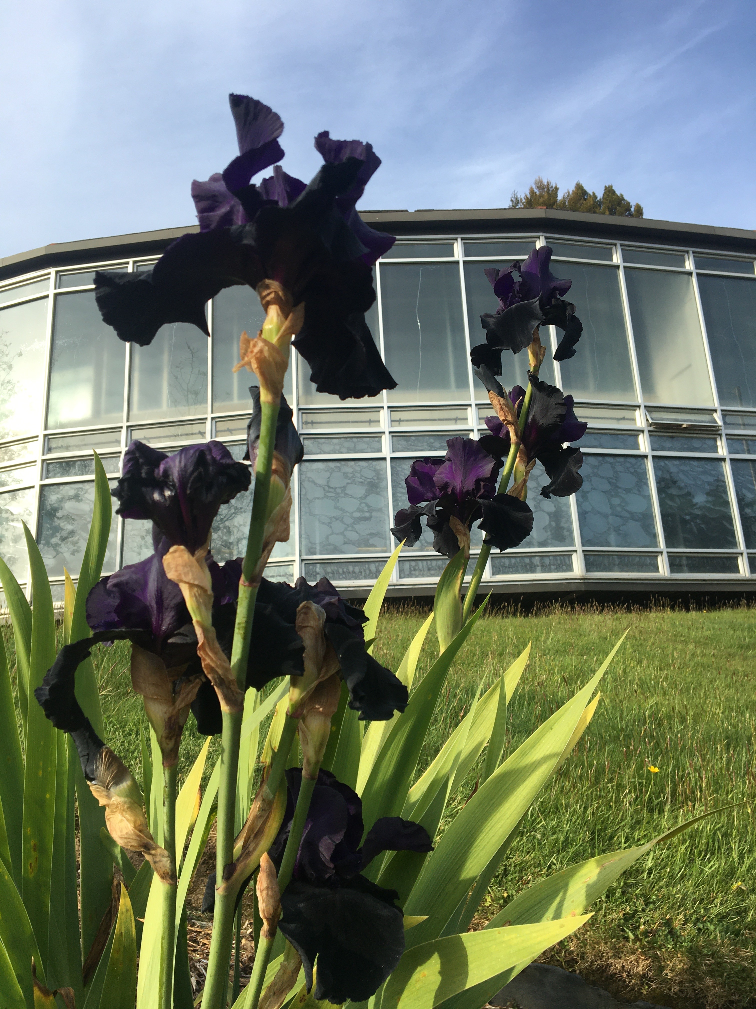
These deep purple petals belong to the bearded iris. In Greek, “iris” means rainbow. The flowers were named after the messenger goddess who traveled using rainbows. Indeed, irises come in a variety of color variants including yellow, orange, peach, pink, black, white, blue, and purple. The deep purple variant pictured here is called Raven’s Girl. The scientific name of the bearded iris is Iris germanica.
Irises have two types of petals. Three petals curve downwards from the center of the flower and are called falls. Three petals stand upright from the flower’s center and are called standards. The two types of petals can be different colors or the same color on an individual flower. Irises have wide, flat, blade-shaped leaves and tall, bare stems.
Irises can be identified based on whether they grow from bulbs or rhizomes. PlantInstructions.com says that rhizomes are horizontal stems that grow underground, branching out from the parent plant, just below the surface of the soil. Rhizomes can be dug up and used to propagate new plants. A bulb is also a modified stem, but it does not grow directly from the parent plant. Most irises grow from rhizomes.
According to GardenFundamentals.com, Irises that grow from rhizomes can be further categorized based on whether they are bearded, crested, or beardless. A beard is a fuzzy patch of hairlike extensions on each fall near the center of the petal, and a crest is a raised section of tissue located in the same place as the beard. If a flower has neither a beard nor a crest, then it is considered beardless.
Most of the larger iris species, including the bearded iris, are native to the Mediterranean, North Africa, and Asia. According to the U.S. Forest Service, there are 28 species of iris that are native to the United States. It is illegal to pick or disturb irises on national forest land.
Irises bloom multiple times a year. Their beautiful flowers can be seen on our campus throughout the summer.
Humboldt County, with its streams and rivers, undeveloped wild spaces, and above-average amount of rain, is an ideal habitat for amphibians.
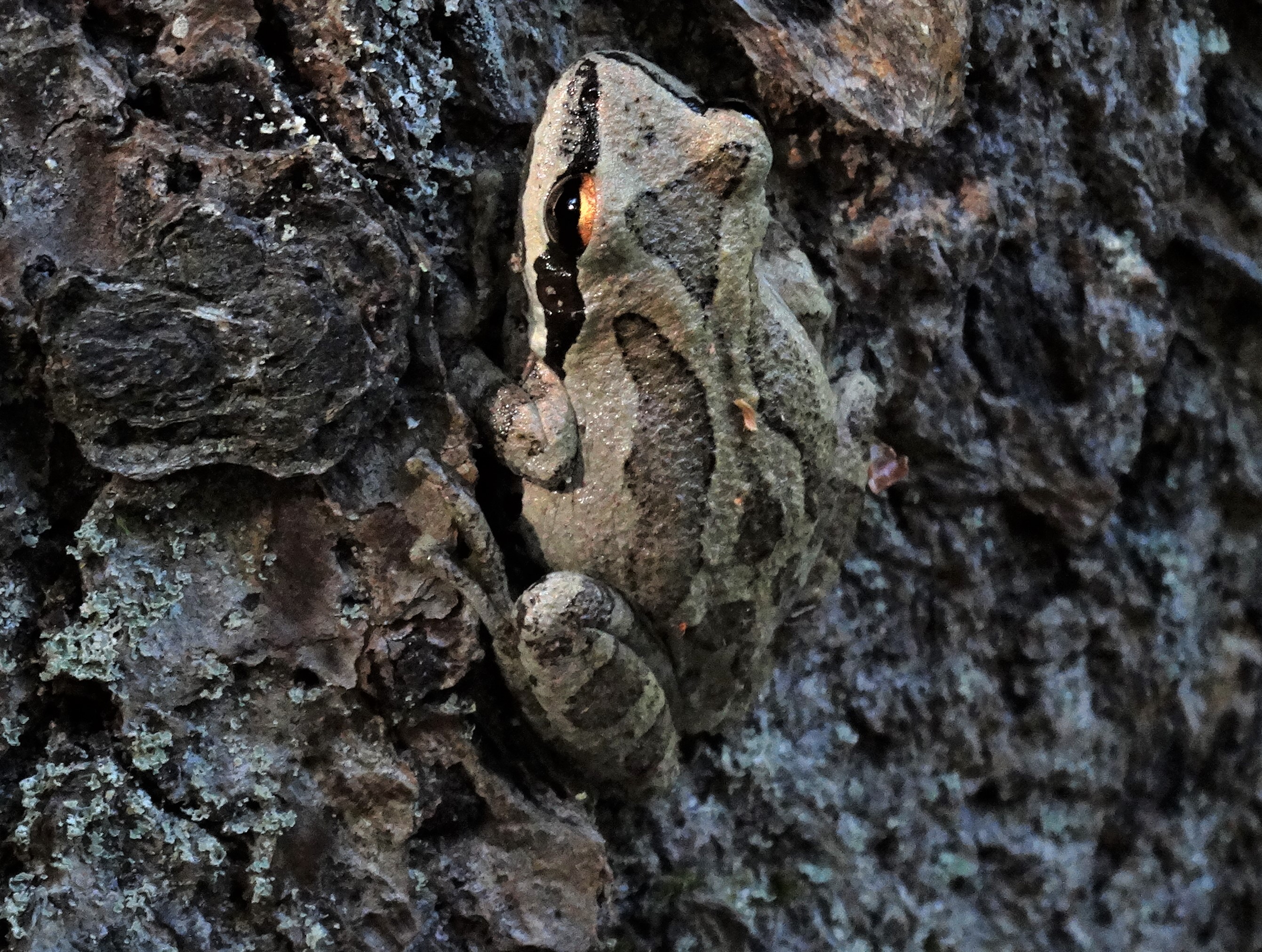
The Pacific tree frog, also known as the Pacific chorus frog, is the most common local frog. Its habitat spans from Northern California to Alaska, and it makes its home in ponds, rivers, forests, grasslands, and even urban settings. The distinctive “ribbit, ribbit” song of the Pacific tree frog can be heard clearly in spring as the male of the species attempts to attract a mate. However, they can be harder to spot than to hear.
“They seem to blend with their background,” said adjunct professor Brian Hudgens of the Cal Poly Humboldt wildlife department. “It’s not as fast as a chameleon, but they do. If you put a green one against a brown background for a couple days and then come back, it will turn brown.”
Less audible is the California red-legged frog, which gives its call underwater and can be found in slow-moving water and ponds. The California red-legged frog has a celebrity history, having been named the California state amphibian and starring in a Mark Twain short story, “The Celebrated Jumping Frog of Calaveras County.” This frog is a threatened species due to habitat loss, despite efforts being made by the state of California and the federal government.
Photo courtesy of Brian Hudgens. A foothill yellow-legged frog pokes its head out of Honeydew Creek.
Another protected frog is the foothill yellow-legged frog, which is a species of concern. The yellow-legged frog lives in streams and, although they vary in coloration, can be identified by their rough skin and habit of jumping into moving water. Their historic range extends from Oregon to Baja California.
“The foothill yellow-legged frogs are breeding now, and you might be able to see egg masses attached to rocks and cobble near the shallow edges of our local rivers,” Hudgens said. “I actually would appreciate hearing if any of your readers see an egg mass and want to pass along the location and any photos.”
While both the California red-legged frog and the foothill yellow-legged frog are listed as threatened or endangered species in the state of California, the Humboldt populations are thriving.
“Most of the places where it lives, or where its historic range covers, are the foothills on the edge of the Central Valley,” Hudgens said of the yellow-legged frog. “And those are areas that are under a lot of developmental pressure, a lot of agricultural pressure, and the rivers and streams around here don’t have the same kind of pressure.”
To help out local frogs, the most important thing you can do is speak out against the development of their natural habitats. Humboldt is a haven for native frog species, and protecting their habitats protects them. When you are in a frog breeding ground, such as a river or pond, it’s important to keep an eye out for eggs and tadpoles underfoot. Washing shoes and swim equipment before and after going to the river can help stop the spread of disease to different populations.
You can create a habitat for frogs in your own backyard. Providing any size pond or standing water can encourage frogs to lay eggs, especially if you live near an existing frog habitat. Hudgens recommends allowing the pond to dry out fully once a year in order to discourage invasive bullfrogs, which prey on native species and compete with them for resources. Bullfrogs take two years to fully mature, while native frogs reach adulthood in a matter of months.
“If you’ve got a stream running through your backyard, maintaining a nice cobble area will really help out the yellow-legged frogs,” Hudgens said. “If you’re in an area with bullfrogs, trying to keep them out is probably the biggest thing we can do for all of our amphibians.”
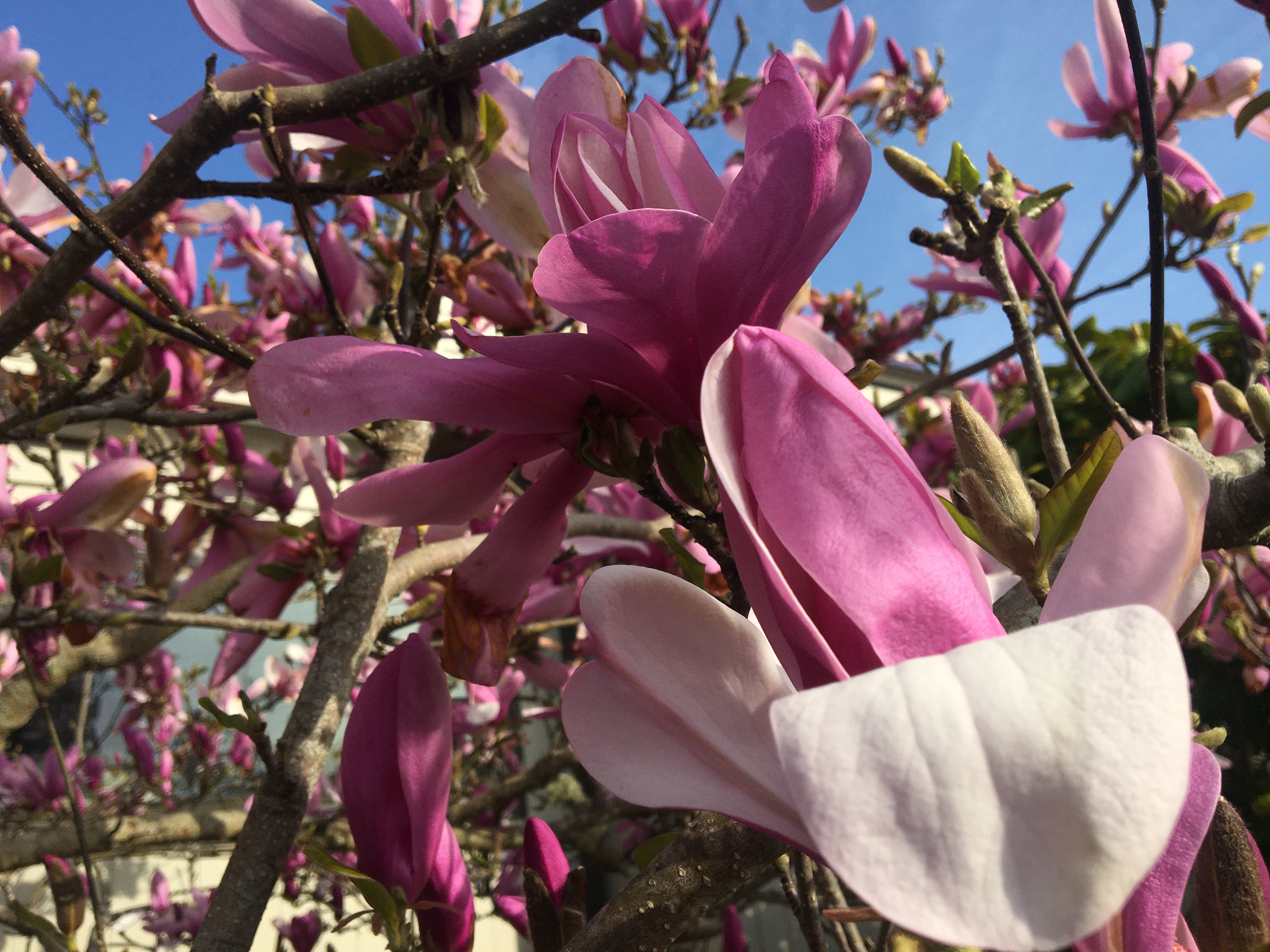
Chinese magnolia trees all over campus have been shedding their flowers, covering walkways in a blanket of magenta and white petals. Their cup-shaped petals range in color from pink to lavender-purple, with white interiors.
Like other species of magnolia, the Chinese magnolia (Magnolia soulangeana) has large, fragrant blooms that grow singularly at the ends of each branch. Because it generally blooms in early spring, the flowers are vulnerable to late freezes.
According to the Missouri Botanical Gardens, the tree blooms from late March to mid-April before the foliage comes in. It can then bloom sporadically throughout the rest of the growing season. The leaves turn from green to yellow in the fall before the tree sheds them for the winter.
Magnolias are considered small trees. According to the North Carolina Extension Gardener, the trees can grow to be 33 feet tall but usually are between 20 and 25 feet tall. They have a sporadic, multi-trunk, shrubby growth pattern. Their bark is dark or light gray in color and has a smooth texture.
The Chinese magnolia has a simple leaf type, with alternating veins. The leaves are oblong shaped and have a margin that extends up the entire length of the leaf. Hairlike structures, or indumentum, are present on the leaves. These hairs help the plant to absorb water and deter predators.
This tree is a hybrid cross between two other magnolia species, M. denudata and M. liliflora. According to Lake Forest College, the hybrid was created by Etienne Soulange-Bodin, an officer in Napoleon’s army who later became a horticulturist. The tree was created in France in 1814.
Though the trees may bloom the rest of the spring and summer, they are currently giving their most beautiful display. Go out and see the magnificent Chinese magnolia today.
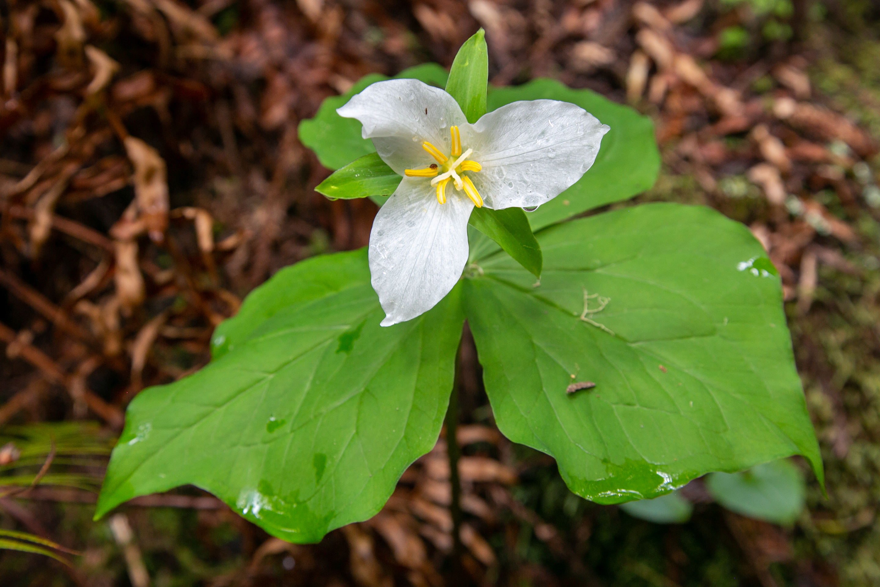
Wandering through the underbrush in the Arcata Community Forest as the daylight slips away, some of the last plants you can make out against the blur of darkening foliage are the pale white faces of Pacific trillium (Trillium Ovatum) looking back at you.
A hallmark of spring in the redwoods, these small white flowers dot the alien ferns in the community forest along trails and sometimes even right in the middle of them.
Trilliums are easy to identify. Their name comes from the latin word tres meaning three, referring to the symmetrical three sets of leaves, petals and sepals that can be found on all 43 species of trillium, 38 of which can be found in North America.
According to the U.S. Forest Service, several species of trillium contain chemical compounds called sapogenins that have been used medicinally through the ages as astringents, coagulants, expectorants, and uterine stimulants. This is evidenced in common names given to some trilliums such as birthwort or birthroot.
The Pacific trillium is widespread across the Pacific Northwest and the northern Rocky Mountains. Although it might be tempting to pick the pretty white blooms along the path, experts advise against damaging the delicate flowers.
Dr. Erik S. Jules, professor of botany and ecology at Cal Poly Humboldt who specializes in plant ecology, said that the Pacific trillium is not endangered, and that it’s doing quite well in the Arcata Community Forest. It is, however, sensitive to disturbances.
“Like the trampling associated with the frisbee golf course in the forest,” Jules said. “So they tend to be less abundant right in those immediate areas.”
Trillium are ephemeral bloomers, which means they flower for a short period of time and go dormant until the next year. Trilliums live for up to 70 years, and damaging them can compromise their ability to bloom again.
“Picking them generally doesn’t kill them, but will definitely reduce their ability to grow and flower the following year, so people should never pick the plant or flower,” Jules said.
The geology colloquium on Monday, March 28began with the introduction of Dr. Jeffery Knott. Knott is an emeritus professor at California State Fullerton and an experienced researcher in paleogeography and paleoclimatology. Paleography is the study of historical geography and paleoclimatology is the study of ancient climates. Combining these studies and biology, Knott shared the research he’s done. He explained how pupfish are so widely spread around the globe using paleogeographic understanding of past lakes and rivers where the pupfish were.
Pupfish are about 2 inches in length and are often a blueish color. This group of species is found in a variety of locations throughout the world. The Death Valley pupfish (Cyprinodon salinus,) which lives exclusively in a small body of water known as Salt Creek, is the focus of Knott’s research.
“[Salt Creek] is mostly a series of pools and sometimes very little ponds to the side, and it’s not very fast-moving as well,” Knott said. “It’s a relatively slow and low gradient stream but this is where one species of pupfish happens to live at the bottom of Death Valley”.
The pupfish at Salt Creek are disconnected from other bodies of water. This makes it impossible for them to be related to pupfish in other parts of the world unless there was a connection to other bodies at some point in the past. This is why comparing the pupfish species proves that sea levels were higher and lakes in the past were big enough to connect these water sources.
To figure out where and when these lakes existed, Knott had to use regional stratigraphy, which studies the layers of rock to determine time frames. Using geological evidence, Knott found that Death Valley had a deepwater lake from around 3.2 to 3.6 million years ago. Along with the timeline of the lakes, the rocks can be used to tell when the area was dried up or whether the lakes were warm.
From there, Knott then compared the timeline set by different sediments to discover when and how the lakes may have overflowed into each other, and where there isn’t overflow there is usually a realistic explanation. Through the study of historical writings, we know that Native Americans moved pupfish into the Devil’s Hole in Death Valley because they used it for a bathing hole.
There have been similar studies done to try and explain the evolutionary relationship between the Deep Springs black toad and the toads at Darwin Canyon. These toads are entirely aquatic, so the distance between these species also has to be explained by the history of lakes in the area.
The next species that Knott and other researchers will focus on are the spring snails. These are a unique case: they move a lot slower than the pupfish and the toads so the distribution of the species is hypothesized to take a lot longer. Finishing the seminar, Knott acknowledged the team that helped him.
“We’ve done a pretty good job of establishing a stratigraphy here in Death Valley in the western Great Basin,” Knott said. “Through the efforts of many, many people, we can correlate this with global climate records, and then we can start to look at the timing of these… lakes.”
The environmental impacts of legal and illegal growing operations are not well understood by many of the residents of Humboldt County, however, it is important that we are aware of how extractive industries impact the environment and all its relatives.
“The rush mentality is what founded Humboldt County…people act like that was a long time ago and we have definitely moved on, [that] we’re this very green friendly place, we’re liberals, we’re leftists,” said Department Chair of Native American Studies, Cutcha Risling Baldy (Yurok/Hupa/Karuk). “This is how people think of Humboldt County, but what founded us is this Gold Rush and we have been rushing ever since…so after the Gold Rush ‘well, gold didn’t make us enough money, lets rush any kind of minerals that we can get’ and then after that ‘well that didn’t make us enough, let’s rush timber’…and I think we’ve been rushing since 1849.”
Assistant professor of Native American Studies Kaitlin Reed (Yurok/Hupa/Oneida) is the author of “From Gold Rush to Green Rush.” In the book, she illustrates the correlation between the destructiveness of the Gold Rush period and the marijuana industry in Humboldt County (Green Rush).
Reed’s presentation “Cannabis & Environmental Justice in Humboldt County,” explains that environmental injustice comes into play when settler-colonial infrastructures further dispossess and exploit Indigenous lands for capital gain.
The marijuana industry perpetuates settler-colonial harm by damaging sensitive ecosystems and cultural areas that Indigenous peoples rely on for survival and health. Just like the Gold Rush, marijuana cultivation poses many threats to Native peoples who rely on the land and rivers for their livelihoods.
According to Reed, trespass cultivation, in which growers illegally occupy public or tribal land to cultivate their grow sites, is the most harmful type of growing operation.
“These types of grows are most frequently associated with the most severe environmental impacts,” Reed said.
Trespass growers hike into the mountains and hills to clear-cut a crop site, which has a devastating impact on the sensitive biodiversity of that natural place. These growing sites are chosen for cover and secrecy, so it’s more likely that a grow sites will disturb highly sensitive bio-diverse ecosystems.
In addition to clear-cutting, growers use and bring certain supplies that are horrible for the environment. These include soil that contains noxious chemicals, herbicides, and insecticides that are released into the earth as well as garbage, plastics, batteries, homemade invasive structures, vehicles, petroleum products, etc.
Additionally, chemicals and other contaminants left by growers poison wildlife species like the West Coast Fisher. Reed explained that rodenticide is an over-the-counter rat poison which causes animals to bleed out internally after consumption.
Research wildlife ecologist Mourad Gabriel led a study in 2015 that examined rodenticide poisoning in the West Coast Fisher population. It was concluded that between 2012 and 2015 the federally threatened species faced an increased number of deaths due to exposure to rodenticide poisoning from illegal pot farms.
Reed explained that rodenticide is usually a slow death, and causes animals to be easy prey for predators. This creates a vicious cycle where the poison gets passed from animal to animal. It’s easier for predators to catch an animal that is slow and weak, and so the contamination process continues through the predator who consumed the poisoned prey.
Indigenous communities are also heavily impacted by trespass grows. During our interview, Reed relayed a story that she heard from the Yurok tribe in which they located several abandoned trespass cultivation sites on their land.
One site had a shocking one hundred five-gallon buckets,overflowing with human feces. Growers will often defecate in rivers, streams, and tributaries. Because marijuana cultivation requires a significant amount of water, the water levels become extremely low, magnifying the effect of those contaminates. Tribal members who consumed the contaminated water were struck with E.coli, including a Yurok Tribal Chairman.
“We ingest the water from our rivers. We’re salmon people, we depend on the fish in those rivers,” said Reed. “In a western framework, there’s a distinction between human beings and nature … settler colonial resource extraction perpetuates violence not only against the landscape but it also perpetuates violence against Indigenous bodies because we depend on that landscape.”
Yurok tribal members are afraid to go out on the land to gather food and other cultural resources in fear of accidentally walking into a grow site, according to Reed. Typically, grow operations are dangerous and harbor some threatening people who will do what they must to protect their crops, including acting violently.
“From a trespass cultivator’s perspective, your goal is to remain undetected. You don’t want anyone to find out what you’re doing or where you are,” Reed said. “It makes little difference if there’s an FBI agent approaching your grow or if it’s an eighty-year-old woman looking for hazelnut sticks.”
She expounded that Indigenous peoples have many reasons to access their ancestral territory: to gather, practice ceremonies, pray and manage landscapes. However, doing so has led to tribal members being subjected to violence from trespass growers.
“There have been stories of tribal members being held at gunpoint because they’ve accidentally stumbled upon a grow,” she continued, “I’ve had people tell me they are scared to go down certain roads in broad daylight because of trespass cultivation.”
Today, around 60% of the marijuana grown in California is grown on public or tribal lands, and the responsibility of cleaning up environmental degradation left by growers falls to Indigenous communities.
One of the most noticeable flowers on the beautiful CPH campus is the Rhododendron. The scientific name of this particular species is Rhododendron delavayi. According to the American Rhododendron society, the plants are native to India, Burma, China, Thailand, and other regions of Eastern Asia. This species of tree is identifiable by its bright red blossoms and elliptical-shaped leaves.
Dense indumentum, or hairlike structures, cover the underside of the plant’s leaves. These help the plant to absorb water and discourage predation by insects.
Photo by Nina Hufman. Bright red Rhododendron blossoms on the tree between the theatre and art buildings on Feb. 15, 2022.
Rhododendrons are members of the Ericaceae, an expansive family which also encompasses cranberries, blueberries, and huckleberries.
Despite the inclusion of these common edible fruits, many other members of this family are known to contain toxic compounds. According to the study ‘Phytochemicals and Biological Activities of Poisonous Genera of Ericaceae in China,’ “the toxic ingredients in the poisonous genera are mainly tetracyclic diterpenes, which exhibit toxic effects on the digestive, cardiovascular and nervous systems.”
The study also states that these poisonous plants’ traditional use in Chinese medicine makes them a good candidate for further scientific study.
According to the National Capital Poison Center, honey produced by bees from rhododendron nectar can concentrate the various toxic chemicals. The effects of poisoning by this method include disorientation, mouth irritation, nausea, and vomiting, leading to it’s colloquial name, “Mad Honey.”
Rhododendron trees can be seen in multiple places on the Cal Poly Humboldt campus including the area between the theater and art buildings, where the above photos were taken. They are considered early bloomers, usually producing flowers from late February to May. Go out while they’re still blooming and enjoy the beautiful, bright red rhododendron.
CCAT courses are back this spring. One of the classes on the roster this semester is Organic Gardening. In this one-unit course, students will learn the basics of gardening. Students grow their plots in the campus community garden using sustainable techniques.
Since the pandemic disrupted CCAT operations, the course has not been offered. Now, the course has returned, and students have a lot of work ahead of them. Ben Cross is a political science major who’s more than excited to be back in the Buckhouse.
“I’ve got lots of passion for this, and it’s an amazing area to learn it,” Cross said. “If there is a place I’d want to take this class, it’s at Humboldt. I want to have my garden and tend to it with confidence.”
Julia Simmons is the student instructor of ENST 123.
“We’re teaching the basics of what goes into gardening,” Simmons said. “I want to focus on how plants affect each other. Some plants have nitrogen-fixing properties and support other plants in the soil. I want to teach students to cultivate ecology and grow food forests.”
Food forests are a farming technique that mimics the natural patterns found in ecosystems. Growing plants interact with each other in a network of reciprocal relationships. The result is healthy biodiversity, nutrient-rich soils, and a sustainable food source.
Agroecologic farming methods have the potential to localize food systems and make them more efficient. A 2018 study titled “Permaculture—Scientific Evidence of Principles for the Agroecological Design of Farming Systems” by the EU Institute for Environmental Science establishes environmental damages caused by industrial agriculture. Monoculture causes biodiversity loss, soil degradation, and alteration of biogeochemical cycles and greenhouse gas emissions. The study cited food forests to remedy the damage done by monoculture.
Monoculture is the standard agricultural practice in the United States. Crops are planted in rows, where they can be most efficiently harvested by machine. Though it is convenient for machinery, this practice does not benefit plants or local ecologies. Without ecological support and context, isolated crops require fertilizers and pesticides to grow.
Plants can fend off pests and fertilize each other in food forests. One example Simmons describes is the three sisters. This pairing of beans, squash and corn, comes from traditional ecologic knowledge.
“They grow really well together, and they use each other to grow well,” Simmons said. “The beans provide nitrogen for the other plants to grow. Ground cover [from the squash leaves] keeps weeds from growing.” The tallest sister, corn, acts as a trellis for the beans to climb up. Growing together, they protect each other and help one another flourish.
“We’re going to be working in the community garden. We’ll design food forests with their own ecologic networks,” Simmons said. “I want anybody to be able to garden, and everyone should garden.”
At Cal Poly Humboldt’s marine lab, graduate students run between the workspaces and laboratories, students stir beakers of brine shrimp instead of cups of coffee, and Percy the giant pacific octopus (Enteroctopus dofleini) tugs on the fingers of the lab tech feeding him.
Photo by Morgan Hancock | Percy the giant Pacific octopus (Enteroctopus dofleini)
Percy’s isn’t the only interesting face one can see at the lab. Other notable critters include Gaia the red octopus (Octopus rubescens), Eleanor the Wolf Eel (Anarrhichthys ocellatus), and Butters the Albino Dungeness Crab (Cancer magister). Sea stars, baby jellyfish, sea urchins, clingfish, nudibranch, sea cucumbers, and anemones are among the lab’s other aquatic residents. There are also rockfish older than most of the people working at the lab.
“There’s so much potential at this place for doing even more than we are now,” said Lab Director Rick Zechman.
Although it’s currently closed to the public due to COVID-19, the students and staff of the Telonicher Marine Lab are offering guided virtual tours and virtual educational programs. Cal Poly Humboldt students also have the option to visit and explore the lab in person.
If they want more experience than a visit will offer, students can sign up for courses in oceanography, fisheries biology, and marine biology, which all include instruction at the marine lab.
Marine naturalist Jordyn Neal is in charge of tours.
“Most of my job is public outreach,” Neal said. “I try to inform the public on the fish here, and conservation.”
Neal gives guided tours of the lab and is in charge of the summer school program. She says that one of her main goals is to bridge the gap of scientific literacy.
Neal is a fifth year marine biology major who is currently doing shark research outside of her degree. She takes CT scans of shark species living at different depths in the water column and looks at the morphology of their ears. Neal’s focus is on how the depth of the water in which a species lives impacts the structure of its ears.
Photo by Morgan Hancock | Eleanor the Wolf Eel (Anarrhichthys ocellatus)
The marine lab also hosts a number of grad students doing research projects, including Rose Harman. Harman is currently working on her master’s thesis and grant applications to fund her research. This summer, Harman will be studying habitat usage and predation of leopard sharks in Humboldt Bay.
“Our new plan is to do field work combined with lab experiments,” Harman said. “One of my goals is to publish my research.”
Graduate students Marzia Fattori and Kalani Ortiz are doing their research on growing bull kelp in Humboldt Bay. Ortiz’s project is focused on kelp as an agricultural product. She is currently growing the seaweed on string, and will be outplanting it to kelp farms in the bay until it reaches a harvestable size.
Fattori’s project is focused on conservation. She is growing bull kelp on gravel and on ceramic tiles to see which substrate is more effective. In the second stage of her research, Fattori will grow the bull kelp in warmer water to examine the impact that rising ocean temperatures will have on kelp populations.
The marine lab has two classrooms, a running seawater system, and access to the Coral Sea, a 90ft research vessel. Lab director Zechman says the lab is situated on an important part of the Pacific coastline, where students can expect a learning experience that is unique to Cal Poly Humboldt.
“Our intention is to be a different kind of polytechnic,” Zechman said. “How many CSUs have a marine lab and a research vessel?”
Cal Poly Humboldt sits on top of a very seismically active part of the world known as a the Cascadia subduction zone. This area is composed of three tectonic plates under the ocean off of the Pacific coast.
The Juan de Fuca, Explorer, and Gorda plates are subducting beneath the continental North American Plate, where the Cal Poly Humboldt campus is located.
As the oceanic plates push against the continental plate, the friction created leads to deformation and faulting.
“We live on that boundary where this is taking place, which leads to frequent earthquake activity,” said Cal Poly Humboldt geology professor Amanda Admire.
In addition to the deformation from the Cascadia subduction zone, the Humboldt region is also influenced by the movement along the San Andreas Fault to the south. Humboldt stands on top of an intersection of three different plates pushing against each other.
The plates themselves move very slowly, only a few centimeters every year. However, they still generate friction as they move against each other. This is the energy released during an earthquake and tsunami.
Graphic by Carlos Pedraza and August Linton
In the Pacific Northwest, both earthquakes and tsunamis are important to prepare for. The Redwood Coast Tsunami Work Group, an organization made up of local government officials, tribes, and relief groups, gives information and warnings in their “Living on Shaking Ground”magazine.
The magazine states that “more than two-thirds of our large historic earthquakes have been located offshore within the Gorda plate.”
A tsunami is created when an earthquake along a fault ruptures the seafloor, moving the entire water column and releasing that built-up energy, which moves out in all directions.
The primary local tsunami hazard, the Cascadia subduction zone, is very close to Humboldt’s coastline compared to other regions in the Pacific Northwest.
According to Admire, a tsunami produced along the fault between the Gorda and North American plates would only take approximately ten minutes to reach the Humboldt shoreline. In Oregon and Washington the fault is further from shore, allowing for more warning time should there be a tsunami.
This much seismic activity can be exciting to study for geologists and scientists, but for people living in Humboldt it may be nerve racking. Admire said there is no need for panic, but that residents should prepare.
The last mega earthquake along the Cascadia subduction zone was in 1700. However, there are still smaller instances of seismic activity as the plates move and push against each other.
So when an earthquake happens: drop, cover and hold on. If you’re near the coastline, head for higher ground in case of a tsunami.
To find more preparedness tools and tsunami evacuation maps for the region, check out the Redwood Coast Tsunami Work Group.
This website uses cookies to improve your experience. We'll assume you're ok with this, but you can opt-out if you wish. Cookie settingsACCEPT
Privacy & Cookies Policy
Privacy Overview
This website uses cookies to improve your experience while you navigate through the website. Out of these cookies, the cookies that are categorized as necessary are stored on your browser as they are essential for the working of basic functionalities of the website. We also use third-party cookies that help us analyze and understand how you use this website. These cookies will be stored in your browser only with your consent. You also have the option to opt-out of these cookies. But opting out of some of these cookies may have an effect on your browsing experience.
Necessary cookies are absolutely essential for the website to function properly. This category only includes cookies that ensures basic functionalities and security features of the website. These cookies do not store any personal information.
Any cookies that may not be particularly necessary for the website to function and is used specifically to collect user personal data via analytics, ads, other embedded contents are termed as non-necessary cookies. It is mandatory to procure user consent prior to running these cookies on your website.